Bolivia
Bolivia[a] /bəˈlɪviə/ (![]() listen), officially the Plurinational State of Bolivia,[b][8][9] is a country in South America. It is land locked by Brazil, Paraguay, Argentina, Peru, and Chile. Luis Alberto Arce Catacora became the president of Bolivia in November 2020.
The population of Bolivia is 8-9 million (2019).
listen), officially the Plurinational State of Bolivia,[b][8][9] is a country in South America. It is land locked by Brazil, Paraguay, Argentina, Peru, and Chile. Luis Alberto Arce Catacora became the president of Bolivia in November 2020.
The population of Bolivia is 8-9 million (2019).
Plurinational State of Bolivia | |
|---|---|
| Motto: "La Unión es la Fuerza" (Spanish) "Unity is Strength"[1] | |
| Anthem: "Himno Nacional de Bolivia" (Spanish) | |
| Dual flag Wiphala | |
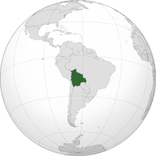
 Location of Bolivia (dark green) in South America (grey) | |
 | |
| Capital | Sucre (constitutional and judicial) La Paz (executive and legislative) |
| Largest city | Santa Cruz 17°48′S 63°10′W / 17.800°S 63.167°W |
| Official languages[2] | |
| Ethnic groups (2009[3]) |
|
| Religion (2018)[4] | 88.9% Christianity —70.0% Roman Catholic —17.2% Protestant —1.7% Other Christian 9.3% No religion 1.2% Other religions 0.6% No answer |
| Demonym(s) | Bolivian |
| Government | Unitary presidential constitutional republic |
| Luis Arce | |
| David Choquehuanca | |
| Legislature | Plurinational Legislative Assembly |
| Chamber of Senators | |
| Chamber of Deputies | |
| Independence | |
• Recognized | 21 July 1847 |
• Admitted to the United Nations | 14 November 1945 |
• Current republic | 7 February 2009 |
| Area | |
• Total | 1,098,581 km2 (424,164 sq mi) (27th) |
• Water (%) | 1.29 |
| Population | |
• census estimate | |
• Density | 10.4/km2 (26.9/sq mi) (224th) |
| GDP (PPP) | 2019 estimate |
• Total | $89.018 billion[5] (88th) |
• Per capita | $7,790[5] (123rd) |
| GDP (nominal) | 2019 estimate |
• Total | $40.687 billion[5] (90th) |
• Per capita | $3,823[5] (117th) |
| Gini (2018) | medium |
| HDI (2019) | medium · 107th |
| Currency | Boliviano (BOB) |
| Time zone | UTC−4 (BOT) |
| Driving side | right |
| Calling code | +591 |
| ISO 3166 code | BO |
| Internet TLD | .bo |
Bolivia is named after Simón Bolívar. The main languages are Spanish and Quechua, but there are other languages too.
History change
Bolivia used to be a colony of Spain. The silver mines in Bolivia made most of Spain's money, and Spain used the Native Bolivians as slaves to work in the mines. After many wars, Simón Bolívar helped Bolivia to be an independent country.
Geography change
Bolivia is 424,135 mi² (1,098,581 km²).[10] This means that Bolivia is the world's 28th-largest country (after Ethiopia). It is the same sort of size as Mauritania.
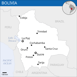
Bolivia is a landlocked nation, which means every border of Bolivia is a border with another country, and so it does not have a sea. It used to own some of the Pacific coast, but it lost it in 1879 in the War of the Pacific. The west of Bolivia is on the Andes mountain range. The highest mountain in Bolivia is called Nevado de Sajama and it is near the city of Oruro. Although this part of the country is very high with lots of mountains, there are also parts of Bolivia which are very flat, and parts of the country which are very near sea level. There is also a bit of Bolivia covered by the Amazon rainforest, and a big lake which is the highest lake in the world. This lake is called Lake Titicaca.
The major cities are La Paz, El Alto, Santa Cruz de la Sierra and Cochabamba. For other places in Bolivia see List of cities in Bolivia.
Demographics change
The population of Bolivia is approximately 10,907,778 people. The ethnic composition of the country is like the following:
- 62%: Native American.
- 26%: Mestizo.
- 10%: White.
- 2%: Black
Economy change
Bolivia suffers from poverty. Over 65% of the population lives below the poverty line.[11]
Divisions change
Bolivia is divided into nine departments. The departments are divided into 112 provinces. The provinces are divided into 339 municipalities and into native community lands.[12]
| Territorial division of Bolivia | ||||||
| Department | Abbreviation (ISO) |
Population | Surface (km²) | Density | Capital city | |
|---|---|---|---|---|---|---|
| Bolivia | BO | 10.027.644 | 1.098.581 | 9,1 | Sucre | |
| Beni | BO-B | 430.049 | 213.564 | 1,9 | Trinidad | |
| Chuquisaca | BO-H | 631.062 | 51.524 | 11,9 | Sucre | |
| Cochabamba | BO-C | 1.786.040 | 55.631 | 22,7 | Cochabamba | |
| La Paz | BO-L | 2.756.989 | 133.985 | 19,9 | La Paz | |
| Oruro | BO-O | 444.093 | 53.558 | 8,2 | Oruro | |
| Pando | BO-N | 75.335 | 63.827 | 1,1 | Cobija | |
| Potosí | BO-P | 780.392 | 118.218 | 6,5 | Potosí | |
| Santa Cruz | BO-S | 2.626.697 | 370.621 | 7,1 | Santa Cruz de la Sierra | |
| Tarija | BO-T | 496.988 | 37.623 | 12,5 | Tarija | |
| Source: Demographic Projections 2008, Bolivian National Demographic Institute.[13] The departmental densitiy has been calculated with the population of 2006. | ||||||
Culture change
Bolivian culture has many Inca, Aymara and other native influences in religion, music and clothing. There is a big festival in Oruro, which is called "El carnaval de Oruro". People in Bolivia like playing football, and football, which is often played in the street. Zoos are also very popular, but they do not have much money.
National symbols change
The Cantuta (often spelled kantuta or qantuta) (Cantua buxifolia or Fuchsia buxifolia) is a flower found in the Yungas, and is the national flower of Bolivia along with the patujú (Heliconia rostrata) found in the tropical regions of Bolivia.
Related pages change
References change
- ↑ "Moneda de 10 Centavos" [10 Cent Coins] (in Spanish). Central Bank of Bolivia. Archived from the original on 28 April 2007. Retrieved 28 January 2014.
- ↑ "Nueva Constitución Política Del Estado > PRIMERA PARTE > TÍTULO I > CAPÍTULO PRIMERO > Modelo De Estado: Ley de Bolivia". JUSTIA Bolivia (in European Spanish). Archived from the original on 25 February 2017. Retrieved 24 February 2017.
- ↑ "South America :: Bolivia". The World Factbook. Central Intelligence Agency. Archived from the original on 13 February 2011. Retrieved 25 March 2017.
- ↑ Religion affiliation in Bolivia as of 2018. Based on Latinobarómetro. Survey period: 15 June to 2 August 2018, 1,200 respondents.
- ↑ 5.0 5.1 5.2 5.3 "Report for Selected Countries and Subjects". www.imf.org. Retrieved 29 August 2020.
- ↑ "GINI index (World Bank estimate) – Bolivia". World Bank. Archived from the original on 11 August 2018. Retrieved 22 March 2020.
- ↑ Human Development Report 2020 The Next Frontier: Human Development and the Anthropocene (PDF). United Nations Development Programme. 15 December 2020. pp. 343–346. ISBN 978-92-1-126442-5. Retrieved 16 December 2020.
- ↑ "Bolivia (Plurinational State of)". World Health Organization. 11 May 2010. Archived from the original on 6 October 2010. Retrieved 30 August 2010.
- ↑ "Bolivia (Plurinational State of)". UNdata. Archived from the original on 2 July 2010. Retrieved 30 August 2010.
- ↑ "World Factbook". Archived from the original on 2014-02-09. Retrieved 2009-06-07.
- ↑ Fenton-Glynn, Claire (2019-04-18). Children's Rights and Sustainable Development: Interpreting the UNCRC for Future Generations. Cambridge University Press. p. 296. ISBN 978-1-107-19302-4.
- ↑ Political Constitution of Bolivia, Article 269
- ↑ "Instituto Nacional de Estadística de Bolivia". Archived from the original on 2008-04-30. Retrieved 2012-03-28.
Notes
- ↑ Spanish: [boˈliβja] ( listen); Guarani: Mborivia [ᵐboˈɾiʋja]; Aymara: Wuliwya [wʊlɪwja]; Quechua: Puliwya [pʊlɪwja]
- ↑ Spanish: Estado Plurinacional de Bolivia Spanish pronunciation: [esˈtaðo pluɾinasjoˈnal de βoˈliβja] ( listen)
Other websites change
- Bolivia map
- Media related to Bolivia at Wikimedia Commons
- Bolivia travel guide from Wikivoyage


