Dufourspitze
highest mountain in Switzerland
The Dufourspitze is a mountain in the Alps.
| Dufourspitze | |
|---|---|
| French: Pointe Dufour, Italian: Punta Dufour | |
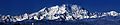
 The Monte Rosa massif with the Dufourspitze. | |
| Highest point | |
| Elevation | 4,634 m (15,203 ft) |
| Prominence | 2,165 m (7,103 ft) ↓ Great St Bernard Pass[1] Ranked 7th in the Alps |
| Isolation | 78.3 km (48.7 mi) → M Blanc de Courmayeur[2] |
| Listing | Country high point Canton high point Ultra Seven Second Summits |
| Coordinates | 45°56′12.6″N 7°52′01.4″E / 45.936833°N 7.867056°E |
| Naming | |
| Native name | Dufourspitze, Höchste Spitze, Gornerhorn Error {{native name checker}}: parameter value is malformed (help) |
| English translation | Peak Dufour, Highest Peak, Large Horn |
| Geography | |
 Dufourspitze Location in Switzerland | |
| Country | Switzerland |
| Canton | Valais |
| Parent range | Pennine Alps |
| Climbing | |
| First ascent | 1 August 1855 by Matthäus and Johannes Zumtaugwald, Ulrich Lauener, Christopher and James Smyth, Charles Hudson, John Birkbeck and Edward Stephenson. |
| Easiest route | rock/snow/ice climb |
With a height of 4634 metres, it is the highest mountain peak in Switzerland and also the second-highest peak in the Alps in and Western Europe after Mont Blanc. The mountain is on the border between Switzerland and Italy.
The mountain is named after the famous swiss engineer and topographer Guillaume Henri Dufour.
Gallery change
-
 Dufourspitze from Nordend
 -
 The Monte-Rosa Hut, from which the routes to the peak start.
 -
 Monte-Rosa massif, the Dufourspitze is the peak in the center.


Notes change
- ↑ Retrieved from the Swisstopo topographic maps. The key col is the Great St Bernard Pass (2,469 m)
- ↑ Retrieved from Google Earth. The nearest point of higher elevation is east of Mont Blanc.