File:MapaSageo-Guayas-02.png
Size of this preview: 433 × 599 pixels. Other resolutions: 173 × 240 pixels | 347 × 480 pixels | 702 × 971 pixels.
Original file (702 × 971 pixels, file size: 55 KB, MIME type: image/png)
| This is a file from the Wikimedia Commons. Information from its description page there is shown below. Commons is a freely licensed media file repository. You can help. |
Summary
| Description |
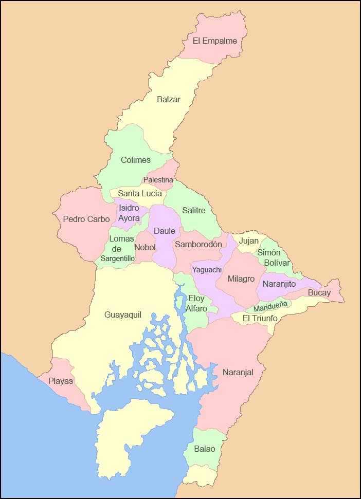
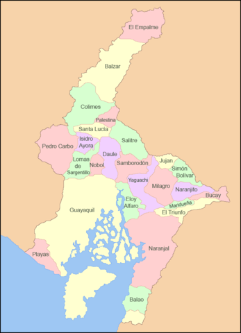
Español: Mapa de los cantones de la Provincia del Guayas |
| Date | |
| Source | Own work |
| Author | Sageo |
Licensing
I, the copyright holder of this work, hereby publish it under the following licenses:

|
Permission is granted to copy, distribute and/or modify this document under the terms of the GNU Free Documentation License, Version 1.2 or any later version published by the Free Software Foundation; with no Invariant Sections, no Front-Cover Texts, and no Back-Cover Texts. A copy of the license is included in the section entitled GNU Free Documentation License. |
This file is licensed under the Creative Commons Attribution-Share Alike 4.0 International, 3.0 Unported, 2.5 Generic, 2.0 Generic and 1.0 Generic license.
- You are free:
- to share – to copy, distribute and transmit the work
- to remix – to adapt the work
- Under the following conditions:
- attribution – You must give appropriate credit, provide a link to the license, and indicate if changes were made. You may do so in any reasonable manner, but not in any way that suggests the licensor endorses you or your use.
- share alike – If you remix, transform, or build upon the material, you must distribute your contributions under the same or compatible license as the original.
You may select the license of your choice.
File history
Click on a date/time to view the file as it appeared at that time.
| Date/Time | Thumbnail | Dimensions | User | Comment | |
|---|---|---|---|---|---|
| current | 05:22, 5 March 2009 | | 702 × 971 (55 KB) | Sageo | {{Information |Description={{es|1=Mapa de los cantones de la Provincia del Guayas}} |Source=trabajo propio (own work) |Author=Sageo |Date=5 de marzo de 2009 |Permission= |other_versions= }} <!--{{ImageUpload|full}}--> Category:Guayas |
File usage
The following page uses this file:
Global file usage
The following other wikis use this file:
- Usage on ar.wikipedia.org
- Usage on arz.wikipedia.org
- Usage on ca.wikipedia.org
- Usage on ceb.wikipedia.org
- Usage on cs.wikipedia.org
- Usage on de.wikipedia.org
- Usage on en.wikipedia.org
- Guayas Province
- Pedro Carbo
- Guayaquil Canton
- Naranjal Canton
- Alfredo Baquerizo Moreno Canton
- Balao Canton
- El Empalme Canton
- El Triunfo Canton
- General Antonio Elizalde Canton
- Isidro Ayora Canton
- Lomas de Sargentillo Canton
- Milagro Canton
- Naranjito Canton
- Palestina Canton
- Pedro Carbo Canton
- Playas Canton
- Samborondón Canton
- Santa Lucía Canton
- Simón Bolívar Canton
- Yaguachi Canton
- Usage on es.wikipedia.org
- Usage on eu.wikipedia.org
- Usage on fa.wikipedia.org
- Usage on id.wikipedia.org
- Usage on incubator.wikimedia.org
View more global usage of this file.