Governors Island
island in the United States of America
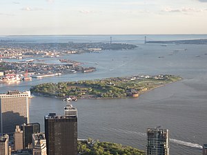
Governors Island is a 172-acre (70 ha) island that lies on the Upper New York Bay, about one-half mile (1 km) from the southern tip of Manhattan Island and away from Brooklyn by Buttermilk Channel. It is legally part of the borough of Manhattan in New York City.
Paggank Noten Eylandt (Nutten Island) | |
|---|---|
 Governors Island viewed from One World Observatory | |
 Location in New York City | |
| Etymology |
|
| Geography | |
| Location | New York Harbor |
| Coordinates | 40°41′29″N 74°0′58″W / 40.69139°N 74.01611°W |
| Area | 172 acres (70 ha) |
| Highest elevation | 70 ft (21 m) |
| Highest point | Outlook Hill |
| Administration | |
| State | New York |
| City | New York City |
| Borough | Manhattan |
| Demographics | |
| Population | 0[1] (2010) |
| Additional information | |
| Time zone | |
| • Summer (DST) | |
| ZIP code | 10004 |
| Official website | The Trust for Governors Island website The Governors Island National Monument website |
Governors Island | |
NYC Landmark
| |
| Location | New York City, New York, U.S. |
| Coordinates | 40°41′29″N 74°0′58″W / 40.69139°N 74.01611°W |
| Area | 172 acres (70 ha) |
| Architectural style | Colonial Revival, Greek Revival |
| Visitation | 800,000 (2018) |
| NRHP reference No. | 85002435 |
| Significant dates | |
| Added to NRHP | February 4, 1985[2] |
| Designated NHL | February 4, 1985 |
| Designated NMON | January 19, 2001 |
| Designated NYCL | June 18, 1996 |
Governors Island was a military base for over three hundred years. Fort Jay is the largest fort there. The island was made bigger by about 82 acres (33 ha) of landfill on its southern side when the first New York City Subway was excavated in the early 20th century.
References change
- ↑ "2010 Census Tracts, Manhattan Community District 1" (PDF). New York City Department of City Planning.
- ↑ "National Register Information System". National Register of Historic Places. National Park Service. 2007-01-23.