Patapsco River
river in Maryland, United States
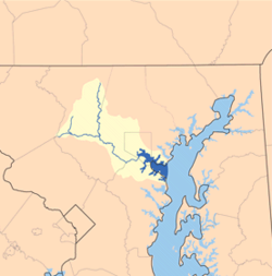
The Patapsco River is a river in the state of Maryland in the United States. It is 39 miles (63 kilometres) long.[1] The name "Patapsco" comes from the language of the Algonquian tribe of Native Americans. The Alginquian word pota-psk-ut means "backwater" or "tide covered with froth."[2]
| Patapsco River Potapskut (Algonquian languages) The River of History | |
|---|---|
 | |
 Patapsco River Watershed | |
| Location | |
| Country | United States |
| State | Maryland |
| Region | Baltimore metropolitan area, Patapsco Valley |
| Cities | Baltimore, Elkridge, Ellicott City |
| Physical characteristics | |
| Source | |
| - location | Marriottsville |
| - coordinates | 39°20′59″N 76°52′56″W / 39.3498272°N 76.8821987°W |
| - elevation | 260 ft (79 m) |
| Mouth | Chesapeake Bay |
| - location | Baltimore |
| - coordinates | 39°10′25″N 76°26′36″W / 39.1737202°N 76.4432935°W |
| - elevation | 0 ft (0 m) |
| Basin size | 632 sq mi (1,640 km2) |
| Basin features | |
| Tributaries | |
| - left | North Branch |
| - right | South Branch |
The river runs through central Maryland and empties into the Chesapeake Bay. The mouth of the river, where it enters the Chesapeake Bay, serves as the city of Baltimore's Inner Harbor. The river has two tributaries. The North Branch runs north. The South Branch runs east and is the northern border of Howard County, Maryland.
Related pages change
Sources change
- ↑ U.S. Geological Survey. National Hydrography Dataset high-resolution flowline data. The National Map Archived 2017-08-23 at the Wayback Machine, accessed April 1, 2011
- ↑ "Ghosts of industrial heyday still haunt Baltimore's harbor, creeks". Chesapeake Bay Journal. Archived from the original on 2018-10-01. Retrieved 2012-09-08.