Rothenfels
Rothenfels is a town in the Main-Spessart district in the Regierungsbezirk of Lower Franconia (Unterfranken) in Bavaria, Germany and a member of the Verwaltungsgemeinschaft (municipal association) of Marktheidenfeld. With a population of just around 1,000 it is said to be Bavaria’s smallest town.
Rothenfels | |
|---|---|
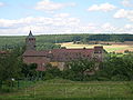
 Rothenfels from the northeast across the Main, Rothenfels Castle in the background | |
 Coat of arms | |
Location of Rothenfels within Main-Spessart district  | |
 Rothenfels  Rothenfels | |
| Coordinates: 49°53′N 9°35′E / 49.883°N 9.583°E | |
| Country | Germany |
| State | Bavaria |
| Admin. region | Unterfranken |
| District | Main-Spessart |
| Municipal assoc. | Marktheidenfeld |
| Government | |
| • Mayor (2020–26) | Michael Gram[1] |
| Area | |
| • Total | 12.07 km2 (4.66 sq mi) |
| Elevation | 154 m (505 ft) |
| Population (2022-12-31)[2] | |
| • Total | 1,012 |
| • Density | 84/km2 (220/sq mi) |
| Time zone | UTC+01:00 (CET) |
| • Summer (DST) | UTC+02:00 (CEST) |
| Postal codes | 97851 |
| Dialling codes | 09393 |
| Vehicle registration | MSP |
| Website | www.rothenfels.de |
Geography change
Location change
Rothenfels is on the Main’s right edge between Lohr and Marktheidenfeld, 5 km north of Marktheidenfeld, and 33 km east of Aschaffenburg. Squeezed as it is between the river and a bluff, the town consists of little more than a main street. Since 2006, the Maindamm, previously part of the railway line Lohr-Wertheim has been used as a town bypass.
Neighbouring communities change
From the north, clockwise: Neustadt am Main, Marktheidenfeld, Hafenlohr, Fürstlich Löwensteinscher Park (gemeindefreies Gebiet).
Subdivisions change
Rothenfels has two Stadtteile, Rothenfels in the valley of the Main and Bergrothenfels on the hill, next to Rothenfels Castle (Burg Rothenfels).
Gallery change
-
 Main street
 -
 Church
 -
 Rothenfels Castle


References change
- ↑ Liste der ersten Bürgermeister/Oberbürgermeister in kreisangehörigen Gemeinden, Bayerisches Landesamt für Statistik, 15 July 2021.
- ↑ Genesis Online-Datenbank des Bayerischen Landesamtes für Statistik Tabelle 12411-003r Fortschreibung des Bevölkerungsstandes: Gemeinden, Stichtag (Einwohnerzahlen auf Grundlage des Zensus 2011) (Hilfe dazu).
Other websites change
- Town’s official webpage Archived 2016-07-09 at the Wayback Machine (in German)
- Rothenfels Castle (in German)