Saar (river)
The Saar (French: Sarre) is a river in northeastern France (Grand Est) and western Germany (Saarland, Rhineland-Palatinate). It is a right tributary of the Moselle River. It rises in the Vosges Mountains in Grand Est and flows northwards into the Moselle near Trier.
| Saar | |
|---|---|
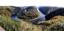
 Saar loop at Mettlach | |
 | |
| Location | |
| Countries | France and Germany |
| Physical characteristics | |
| Source | Sarre Blanche |
| - location | Vosges mountains, Bas-Rhin |
| - coordinates | 48°31′37″N 7°09′45″E / 48.52694°N 7.16250°E |
| - elevation | ±800 m (2,600 ft) |
| 2nd source | Sarre Rouge |
| - location | Vosges mountains, Moselle |
| - coordinates | 48°32′05″N 7°10′05″E / 48.53472°N 7.16806°E |
| - elevation | ±670 m (2,200 ft) |
| Mouth | |
| - location | Moselle |
| - coordinates | 49°42′5″N 6°34′11″E / 49.70139°N 6.56972°E |
| Length | 246 km (153 mi) |
| Basin size | 7,431 km2 (2,869 sq mi) |
| Discharge | |
| - average | 75 m3/s (2,600 cu ft/s) |
| Basin features | |
| Progression | Moselle→ Rhine→ North Sea |
The first written mention of the Saar, in Latin language as Saravus, is found in the poem Mosella by the Roman poet Decimus Magnus Ausonius.[1]
Geography change
With a length of 246 km (153 mi),[N 1] it is the largest tributary of the Moselle river. Its drainage basin has an area of approximately 7,431 km2 (2,869 sq mi).
Course change
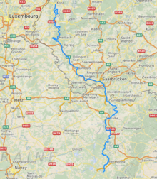
The Saar river is born at the foot of Mont Donon, the highest peak of the northern Vosges Mountains. It flows first for about 126 km (78 mi) through the French region of Grand Est. The Saar marks the border between France and Germany for about 11 km (7 mi) from its confluence with the Blies, between the towns of Sarreguemines and Saarbrücken and goes into German territory.
Then the river flows about 68 km (42 mi) through the Saarland, and about 31 km (19 mi) through the Rhineland-Palatinate and, finally, flows into the Moselle at Konz between Trier and the Luxembourg border.
Upper Saar change
The Sarre Rouge (Red Saar) and Sarre Blanche (White Saar) are considered as the two source rivers of the Saar.
The Red and the White Saar have their sources on Donon, less than 1 km (1 mi) distance apart. The source of the White Saar is near the town of Grandfontaine (Bas-Rhin department), and the source of the Red Saar is near the town of Abreschviller, (Moselle department). The confluence of the two rivers is near Hermelange (48°40′46″N 07°01′01″E / 48.67944°N 7.01694°E), south of Sarrebourg.[N 2]
| Discharge | Length | Watershed | Source height |
Coordinates | |
|---|---|---|---|---|---|
| Red Saar[2] | 1.86 m³/s | 26.8 km | 107.3 km² | 785 m | 48°32′4.3″N 07°2.7′0″E / 48.534528°N 7.04500°E |
| White Saar[2] | 1.60 m³/s | 26.6 km[3] | 80.4 km² | 710 m | 48°31′37″N 07°09′45″E / 48.52694°N 7.16250°E |
The Saar river, and its two source rivers, flow first through the Moselle department, in the Lorraine region; then, for a short distance, flow through the Bas-Rhin department, in the Grand Est region. From Sarrealbe to Sarreguemines, the Saar flows along the border with Germany. At Sarreguemines, the Blies river, the largest tributary of the Saar, flows into the Saar and its discharge rises from 20.9 m³/s to 41.5 m³/s.[2]
Middle and lower Saar change
From Sarreguemines, the Saar is navigable (it is deep, wide and slow enough for a ship to pass). Then the Saar gets into German territory forming a narrow valley through the western Rhenish Massif. At its beginning in this region, it forms the famous Saar loop (German: Saarschleife) at Mettlach.
After 246 km (129 km in France,[4] and 117 km in Germany) the Saar flows into the Moselle river at Konz (Rhineland-Palatinate) between Trier and the Luxembourg border.
Grapes, to produce wine, are grown along the lower Saar, mainly between Serrig and Konz.
Tributaries of the Saar change
Some of the important tributaries of the Saar are:
|
Left tributaries: |
Right tributaries |
Towns along the river change
Some towns and cities found along the river are:
| France | Départments | Towns and cities |
|---|---|---|
| Moselle | Abreschviller (Sarre Rouge), Lorquin, Sarrebourg, Fénétrange | |
| Bas-Rhin | Sarre-Union | |
| Moselle | Sarralbe, Sarreguemines | |
| Germany | Bundesländer | Towns and cities |
| Saarland | Saarbrücken, Völklingen, Wadgassen, Bous, Saarlouis, Dillingen, Merzig | |
| Rhineland-Palatinate | Saarburg, Konz |
Gallery change
Related pages change
Notes change
- ↑ This is the length including the White Saar, following SANDRE, the French official organism; other organisms give a shorter length because they start to measure from the confluence of the White and the Red Saar rivers.
- ↑ Because SANDRE, the French official organism, considers the White Saar as the upper part of the Saar river, the Red Saar is considered a tributary of the White Saar - Saar river.
References change
- ↑ "Wiki text and translation of the poem Mosella". Archived from the original on 2023-04-17. Retrieved 2013-11-05.
- ↑ 2.0 2.1 2.2 "Débits Caracteristiques en m3/s" (PDF) (in French). Agence de l'Eau Rhin-Meuse. 2000. Archived from the original (PDF) on 17 May 2014. Retrieved 3 November 2013.
- ↑ Länge in Teilstrecken[permanent dead link]
- ↑ "La Sarre (A9--0100)" (in French). SANDRE - Portail national d'accès aux référentiels sur l'eau. Archived from the original on 13 December 2014. Retrieved 4 November 2013.
- ↑ "Ruisseau de Gondrexange (A9020440)" (in French). SANDRE - Portail national d'accès aux référentiels sur l'eau. Archived from the original on 23 January 2016. Retrieved 4 November 2013.
- ↑ "Ruisseau le Landbach (A9040380)" (in French). SANDRE - Portail national d'accès aux référentiels sur l'eau. Archived from the original on 23 January 2016. Retrieved 4 November 2013.
- ↑ "Ruisseau le Naubach (A9080300)" (in French). SANDRE - Portail national d'accès aux référentiels sur l'eau. Archived from the original on 23 January 2016. Retrieved 4 November 2013.
- ↑ "L'Albe (A91-0200)" (in French). SANDRE - Portail national d'accès aux référentiels sur l'eau. Archived from the original on 10 June 2015. Retrieved 4 November 2013.
- ↑ "Ruisseau la Rosselle (A95-0200)" (in French). SANDRE - Portail national d'accès aux référentiels sur l'eau. Archived from the original on 17 January 2016. Retrieved 4 November 2013.
- ↑ "Ruisseau Bruchbach (A9600440)" (in French). SANDRE - Portail national d'accès aux référentiels sur l'eau. Retrieved 4 November 2013.[permanent dead link]
- ↑ "La Nied (A9--0120)" (in French). SANDRE - Portail national d'accès aux référentiels sur l'eau. Archived from the original on 26 May 2012. Retrieved 4 November 2013.
- ↑ "La Bievre (A9030300)" (in French). SANDRE - Portail national d'accès aux référentiels sur l'eau. Archived from the original on 10 June 2015. Retrieved 4 November 2013.
- ↑ "L'Isch (A90-0210)" (in French). SANDRE - Portail national d'accès aux référentiels sur l'eau. Archived from the original on 4 March 2016. Retrieved 4 November 2013.
- ↑ "Ruisseau l'Eichel (A92-0200)" (in French). SANDRE - Portail national d'accès aux référentiels sur l'eau. Archived from the original on 22 December 2015. Retrieved 4 November 2013.
- ↑ "La Blies (A93-0200)" (in French). SANDRE - Portail national d'accès aux référentiels sur l'eau. Archived from the original on 3 March 2016. Retrieved 4 November 2013.
Other websites change
- MULEWF Rheinland-Pfalz: Saar Archived 2013-03-14 at the Wayback Machine (in German)