Sarlat-la-Canéda
Sarlat-la-Canéda (Occitan: Sarlat e La Canedat),[2] or simply Sarlat, is a town and commune in southwestern France, in the region of Aquitaine. It is a subprefecture of the Dordogne department.
Sarlat-la-Canéda | |
|---|---|
Subprefecture and commune | |
 Sarlat old city | |
.svg) Coat of arms | |
Location of Sarlat-la-Canéda  | |
 Sarlat-la-Canéda  Sarlat-la-Canéda | |
| Coordinates: 44°53′34″N 1°12′55″E / 44.8928°N 1.2153°E | |
| Country | France |
| Region | Nouvelle-Aquitaine |
| Department | Dordogne |
| Arrondissement | Sarlat-la-Canéda |
| Canton | Sarlat-la-Canéda |
| Intercommunality | Sarlat-Périgord noir |
| Government | |
| • Mayor (2014–2020) | Jean-Jacques de Peretti[1] |
| Area 1 | 47.13 km2 (18.20 sq mi) |
| Population (2014) | 9,127 |
| • Density | 190/km2 (500/sq mi) |
| Demonym | Sarladais |
| Time zone | UTC+01:00 (CET) |
| • Summer (DST) | UTC+02:00 (CEST) |
| INSEE/Postal code | 24520 /24200 |
| Elevation | 102–319 m (335–1,047 ft) (avg. 211 m or 692 ft) |
| Website | www.sarlat.fr |
| 1 French Land Register data, which excludes lakes, ponds, glaciers > 1 km2 (0.386 sq mi or 247 acres) and river estuaries. | |
History change
The city developed around a Carolingian Benedictine abbey in the 13th century. The abbey already existed in the 9th century. it was part of the six great abbeys of the old province of Périgord. The others were Paunat, Belvès, Saint Front de Périgueux, Brantôme and Terrasson. The Carolingian abbey was the only one to be spared by the Vikings because it does not lie on the Dordogne river or its tributaries. In 1317, Sarlat became the seat of a bishop.
The city was badly damaged in the Hundred Years' War. After several conflicts it was rebuilt in Renaissance style between 1450 and 1500. In the middle of the 17th century, the city lost political influence and became poorer.
On 1 March 1965, the communes of Sarlat and of La Canéda were combined in one commune with the name of Sarlat-la-Canéda.[3]
Sports change
Sports clubs:
- Rugby Union: Sarlat Rugby.
Geography change
The commune of Sarlat-la-Canéda has an area of 47.13 km2 (18.20 sq mi) and its average altitude is 211 m (692 ft); at the city hall, the altitude is 129 m (423 ft).[4]

|
Sarlat-la-Canéda is surrounded by the communes Tamniès, Marquay. Marcillac-Saint-Quentin, Proissans, Sainte-Nathalène, Saint-Vincent-le-Paluel, Carsac-Aillac, Vitrac, Vézac and Saint-André-d'Allas.
Climate change
Sarlat-la-Canéda has an oceanic climate with template summers (Köppen climate classification: Cfb).
Population change
The inhabitants of Sarlat-la-Canéda are known, in French, as Sarladais (women: Sarladaises).[5]
With a population of 9,127 (2014),[6] Sarlat-la-Canéda has a population density of 194 inhabitants/km2.
Evolution of the population in Sarlat-la-Canéda

Sarlat-la-Canéda forms the urban area of Sarlat-la-Canéda with a population of 9,259 inhabitants (2013) and an area of 47.1 km2 (18.2 sq mi).[7] This urban area is the centre of the metropolitan area of Sarlat-la-Canéda, formed by 17 communes with a population of 19,520 inhabitants (2013) and an area of 277.8 km2 (107.3 sq mi).[8]
Administration change
Sarlat-la-Canéda is a subprefecture of the Dordogne and the capital of the arrondissement of Sarlat-la-Canéda.
The commune is the administrative centre (French: chef-lieu) of the canton of Sarlat-la-Canéda', formed with 13 communes.[9]
It is part of the intercommunality Sarlat-Périgord Noir (French: Communauté de communes Sarlat-Périgord Noir).
= Important people from the city change
- Étienne de La Boétie (1530-1563), lawyer and writer
- Henry Sanfourche (1775-1841), colonel of the French Empire.
- Gautier de Costes de La Calprenède (about 1610-1663), writer
- Pierre Lachambeaudie (1807-1872), poet
- Gabriel Tarde (1843-1904), social scientist
Gallery change
-
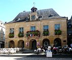 Sarlat city hall
 -
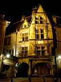 House of La Boétie.
 -

-
 Lantern des Morts.
 -
 La cour des Chanoines.


Related pages change
References change
- ↑ "Vos élus". Ville de Sarlat. Retrieved 11 March 2017.
- ↑ "SARLAT E LA CANEDAT" (in French). Le nom occitan des communes du Périgord. Retrieved 10 April 2015.[permanent dead link]
- ↑ "Commune de Sarlat-la-Canéda (24520)". Code Officiel Géographique (in French). Institut national de la statistique et des études économiques - INSEE. Retrieved 10 April 2015.
- ↑ "City of Sarlat-la-Canéda". Map-France.com. Retrieved 10 April 2015.
- ↑ "Sarlat-la-Canéda (24200)" (in French). habitants.fr. Retrieved 10 April 2015.
- ↑ "Régions, départements, arrondissements, cantons et communes" (PDF). Populations légales 2014 (in French). Institut national de la statistique et des études économiques - INSEE. Retrieved 11 March 2017.
- ↑ "Unité urbaine de Sarlat-la-Canéda (24205)". Comparateur de territoire (in French). Institut national de la statistique et des études économiques - INSEE. Retrieved 11 March 2017.
- ↑ "Aire urbaine de Sarlat-la-Canéda (258)". Comparateur de territoire (in French). Institut national de la statistique et des études économiques - INSEE. Retrieved 11 March 2017.
- ↑ "Canton de Sarlat-la-Canéda (2418)". Géographie administrative et d’étude (in French). Institut national de la statistique et des études économiques - INSEE. Retrieved 11 March 2017.
Other websites change
- Ville de Sarlat-la-Canéda - Official site (in French)
- Tourist office website
- Departamental Council of Dordogne (in French)
- Prefecture official website (in French)
- Région Nouvelle-Aquitaine (in French)