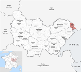
Arrondissement of Belfort
arrondissement of France
The arrondissement of Belfort is an arrondissement in the Bourgogne-Franche-Comté region of France. It is the only arrondissement of the Territoire de Belfort department.
Belfort | |
|---|---|
 Location within the region Bourgogne-Franche-Comté | |
| Country | France |
| Region | Bourgogne-Franche-Comté |
| Department | Territoire de Belfort |
| No. of communes | 101 |
| Prefecture | Belfort |
| Area | 609.4 km2 (235.3 sq mi) |
| Population (Jan. 2019)[1] | 141,318 |
| INSEE code | 901 |
Composition change
Cantons change
The cantons in the arrondissement of Belfort are:
- Bavilliers (9001)
- Belfort-1 (9002)
- Belfort-2 (9003)
- Belfort-3 (9004)
- Châtenois-les-Forges (9005)
- Delle (9006)
- Giromagny (9007)
- Grandvillars (9008)
- Valdoie (9009)
Communes change
The communes of the arrondissement of Belfort are:[2]
- Andelnans (90001)
- Angeot (90002)
- Anjoutey (90003)
- Argiésans (90004)
- Autrechêne (90082)
- Auxelles-Bas (90005)
- Auxelles-Haut (90006)
- Banvillars (90007)
- Bavilliers (90008)
- Beaucourt (90009)
- Belfort (90010)
- Bermont (90011)
- Bessoncourt (90012)
- Bethonvilliers (90013)
- Boron (90014)
- Botans (90015)
- Bourg-sous-Châtelet (90016)
- Bourogne (90017)
- Brebotte (90018)
- Bretagne (90019)
- Buc (90020)
- Charmois (90021)
- Chaux (90023)
- Chavanatte (90024)
- Chavannes-les-Grands (90025)
- Châtenois-les-Forges (90022)
- Chèvremont (90026)
- Courcelles (90027)
- Courtelevant (90028)
- Cravanche (90029)
- Croix (90030)
- Cunelières (90031)
- Danjoutin (90032)
- Delle (90033)
- Denney (90034)
- Dorans (90035)
- Eguenigue (90036)
- Essert (90039)
- Faverois (90043)
- Felon (90044)
- Florimont (90046)
- Fontaine (90047)
- Fontenelle (90048)
- Foussemagne (90049)
- Frais (90050)
- Froidefontaine (90051)
- Fêche-l'Église (90045)
- Giromagny (90052)
- Grandvillars (90053)
- Grosmagny (90054)
- Grosne (90055)
- Joncherey (90056)
- Lachapelle-sous-Chaux (90057)
- Lachapelle-sous-Rougemont (90058)
- Lacollonge (90059)
- Lagrange (90060)
- Lamadeleine-Val-des-Anges (90061)
- Larivière (90062)
- Lebetain (90063)
- Lepuix (90065)
- Lepuix-Neuf (90064)
- Leval (90066)
- Menoncourt (90067)
- Meroux (90068)
- Montbouton (90070)
- Montreux-Château (90071)
- Morvillars (90072)
- Moval (90073)
- Méziré (90069)
- Novillard (90074)
- Offemont (90075)
- Petit-Croix (90077)
- Petitefontaine (90078)
- Petitmagny (90079)
- Phaffans (90080)
- Pérouse (90076)
- Recouvrance (90083)
- Reppe (90084)
- Riervescemont (90085)
- Romagny-sous-Rougemont (90086)
- Roppe (90087)
- Rougegoutte (90088)
- Rougemont-le-Château (90089)
- Réchésy (90081)
- Saint-Dizier-l'Évêque (90090)
- Saint-Germain-le-Châtelet (90091)
- Sermamagny (90093)
- Sevenans (90094)
- Suarce (90095)
- Thiancourt (90096)
- Trévenans (90097)
- Urcerey (90098)
- Valdoie (90099)
- Vauthiermont (90100)
- Vellescot (90101)
- Vescemont (90102)
- Villars-le-Sec (90105)
- Vétrigne (90103)
- Vézelois (90104)
- Éloie (90037)
- Étueffont (90041)
- Évette-Salbert (90042)
The communes with more inhabitants in the arrondissement are:
| INSEE code |
Commune | Population[3] (2014) |
Canton | Intercommunality |
|---|---|---|---|---|
| 90010 | Belfort | 49,764 | Belfort-1, Belfort-2 and Belfort-3 |
CA Grand Belfort |
| 90033 | Delle | 5,773 | Delle | Le Sud Territoire |
| 90099 | Valdoie | 5,391 | Valdoie | CA Grand Belfort |
| 90009 | Beaucourt | 5,047 | Delle | Le Sud Territoire |
| 90008 | Bavilliers | 4,838 | Bavilliers | CA Grand Belfort |
| 90075 | Offemont | 3,690 | Valdoie | CA Grand Belfort |
| 90032 | Danjoutin | 3,675 | Bavilliers | CA Grand Belfort |
| 90039 | Essert | 3,189 | Bavilliers | CA Grand Belfort |
| 90052 | Giromagny | 3,141 | Giromagny | Les Vosges du Sud |
| 90053 | Grandvillars | 2,968 | Grandvillars | Le Sud Territoire |
Related pages change
References change
- ↑ "Téléchargement du fichier d'ensemble des populations légales en 2019". The National Institute of Statistics and Economic Studies. 28 December 2020.
- ↑ "Arrondissement de Belfort (901)". Géographie administrative et d'étude (in French). Institut national de la statistique et des études économiques - INSEE. Retrieved 23 July 2017.
- ↑ "Comparateur de territoire, géographie au 01/01/2019". INSEE. Retrieved 2019-10-04.