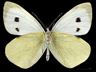
File:(MHNT) Pieris brassicae - Ste.Foy d'Aigrefeuille Haute Garonne France - male ventral.jpg

Size of this preview: 797 × 600 pixels. Other resolutions: 319 × 240 pixels | 638 × 480 pixels | 1,020 × 768 pixels | 1,280 × 963 pixels | 2,560 × 1,927 pixels | 7,594 × 5,716 pixels.
Original file (7,594 × 5,716 pixels, file size: 25.92 MB, MIME type: image/jpeg)
| This is a file from the Wikimedia Commons. Information from its description page there is shown below. Commons is a freely licensed media file repository. You can help. |

|
This image has been assessed under the valued image criteria and is considered the most valued image on Commons within the scope: Pieris brassicae - mounted specimen - male ventral. You can see its nomination here. |
|
Pieris brassicae (Linnaeus, 1758) |
| Photographer | ||||||||||||||||||||||||
| Description |
Deutsch: Pieris brassicae - Ventralansicht English: Pieris brassicae - Ventral side Français : Pieris brassicae - Face ventrale |
|||||||||||||||||||||||
| Gender | Male | |||||||||||||||||||||||
| Place of discovery |
|
|||||||||||||||||||||||
| Date | Taken on 18 January 2023 | |||||||||||||||||||||||
| Collection |
|
|||||||||||||||||||||||
| Accession number |
MHNT CUT 2022 14 2 |
|||||||||||||||||||||||
| Source | Own work | |||||||||||||||||||||||
| Permission (Reusing this file) |
I, the copyright holder of this work, hereby publish it under the following license: This file is licensed under the Creative Commons Attribution-Share Alike 4.0 International license.
|
|||||||||||||||||||||||
| Other versions |
|
|||||||||||||||||||||||

_Pieris_brassicae_-_Ste.Foy_d%27Aigrefeuille_Haute_Garonne_France_-_male.jpg)
_Pieris_brassicae_-_Ste.Foy_d%27Aigrefeuille_Haute-Garonne_France_-_male_dorsal.jpg)
_Pieris_brassicae_-_Ste.Foy_d%27Aigrefeuille_Haute_Garonne_France_-_male_ventral.jpg)
_Pieris_brassicae_-_Ste.Foy_d%27Aigrefeuille_Haute_Garonne_France_-_male_ventral.jpg)
_Pieris_brassicae_-_Ste.Foy_d%27Aigrefeuille_Haute_Garonne_France_-_male_ventral.jpg)
Focus stacking of 4 pictures.
| Camera location | | View this and other nearby images on: OpenStreetMap |
|---|
_Pieris_brassicae_-_Ste.Foy_d%27Aigrefeuille_Haute_Garonne_France_-_male_ventral.jpg¶ms=043.841738_N_0001.389978_E_globe:Earth_type:camera__&language=en)

|
This document was made as part of the Projet Phoebus.
|
File history
Click on a date/time to view the file as it appeared at that time.
| Date/Time | Thumbnail | Dimensions | User | Comment | |
|---|---|---|---|---|---|
| current | 20:24, 21 February 2023 | | 7,594 × 5,716 (25.92 MB) | Archaeodontosaurus | {{Information |Description= |Source={{own}} |Date= |Author= Archaeodontosaurus |Permission= |other_versions= }} |
File usage
The following page uses this file:
Global file usage
The following other wikis use this file:
- Usage on als.wikipedia.org
- Usage on an.wikipedia.org
- Usage on ast.wikipedia.org
- Usage on az.wikipedia.org
- Usage on bat-smg.wikipedia.org
- Usage on ba.wikipedia.org
- Usage on be.wikipedia.org
- Usage on bg.wikipedia.org
- Usage on ca.wikipedia.org
- Usage on ceb.wikipedia.org
- Usage on cs.wikipedia.org
- Usage on cy.wikipedia.org
- Usage on da.wikipedia.org
- Usage on de.wikipedia.org
- Usage on en.wikipedia.org
- Usage on eo.wikipedia.org
- Usage on es.wikipedia.org
- Usage on eu.wikipedia.org
- Usage on fi.wikipedia.org
- Usage on fr.wikipedia.org
- Usage on fy.wikipedia.org
- Usage on gl.wikipedia.org
- Usage on gv.wikipedia.org
- Usage on hsb.wikipedia.org
- Usage on hu.wikipedia.org
- Usage on hy.wikipedia.org
- Usage on it.wikipedia.org
- Usage on ja.wikipedia.org
- Usage on kk.wikipedia.org
- Usage on la.wikipedia.org
- Usage on lb.wikipedia.org
- Usage on lt.wikipedia.org
- Usage on mhr.wikipedia.org
- Usage on mk.wikipedia.org
- Usage on nl.wikipedia.org
- Usage on no.wikipedia.org
- Usage on os.wikipedia.org
- Usage on pl.wikipedia.org
- Usage on pms.wikipedia.org
- Usage on pt.wikipedia.org
- Usage on ro.wikipedia.org
- Usage on sco.wikipedia.org
- Usage on sl.wikipedia.org
- Usage on sq.wikipedia.org
- Usage on sr.wikipedia.org
- Usage on sv.wikipedia.org
- Usage on szl.wikipedia.org
- Usage on tg.wikipedia.org
- Usage on tr.wikipedia.org
View more global usage of this file.
_Pieris_brassicae_-_Ste.Foy_d%27Aigrefeuille_Haute_Garonne_France_-_male_ventral.jpg)
_Pieris_brassicae_-_Ste.Foy_d%27Aigrefeuille_Haute_Garonne_France_-_male_ventral.jpg)