File:AU-map-en.jpg

Size of this preview: 559 × 600 pixels. Other resolutions: 224 × 240 pixels | 447 × 480 pixels | 716 × 768 pixels | 954 × 1,024 pixels | 1,312 × 1,408 pixels.
Original file (1,312 × 1,408 pixels, file size: 209 KB, MIME type: image/jpeg)
| This is a file from the Wikimedia Commons. Information from its description page there is shown below. Commons is a freely licensed media file repository. You can help. |
Summary
| Description |
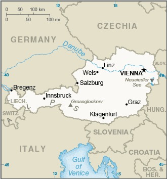
Čeština: Mapa Rakouska
English: Map of Austria
Deutsch: Landkarte Österreichs
Русский: Карта Австрии |
| Date | |
| Source | CIA World Factbook |
| Author | United States Central Intelligence Agency |
Licensing
This image is in the public domain because it contains materials that originally came from the United States Central Intelligence Agency's World Factbook.
|
 |
File history
Click on a date/time to view the file as it appeared at that time.
| Date/Time | Thumbnail | Dimensions | User | Comment | |
|---|---|---|---|---|---|
| current | 15:08, 24 December 2022 | | 1,312 × 1,408 (209 KB) | Kontrollstellekundl | min. size |
| 23:27, 29 May 2021 |  | 330 × 354 (31 KB) | Martin Tauchman | Uploaded a work by United States Central Intelligence Agency from [https://www.cia.gov/the-world-factbook/static/ca4746294b6ce0a6b96414f296b1ddba/AU-map.jpg CIA World Factbook] with UploadWizard |
File usage
The following 3 pages use this file:
Global file usage
The following other wikis use this file:
- Usage on ab.wikipedia.org
- Usage on af.wikipedia.org
- Usage on arz.wikipedia.org
- Usage on bcl.wikipedia.org
- Usage on be-tarask.wikipedia.org
- Usage on bg.wiktionary.org
- Usage on bh.wikipedia.org
- Usage on bn.wikipedia.org
- Usage on bn.wiktionary.org
- Usage on br.wikipedia.org
- Usage on bs.wikipedia.org
- Usage on ca.wikipedia.org
- Usage on cy.wiktionary.org
- Usage on da.wikipedia.org
- Usage on dsb.wikipedia.org
- Usage on el.wikipedia.org
- Usage on en.wikipedia.org
- Usage on en.wiktionary.org
- Usage on fa.wikipedia.org
- Usage on fa.wiktionary.org
- Usage on fi.wikivoyage.org
- Usage on fr.wiktionary.org
- Usage on gl.wikipedia.org
- Usage on gom.wikipedia.org
- Usage on hyw.wikipedia.org
- Usage on ilo.wikipedia.org
- Usage on ja.wikipedia.org
- Usage on ka.wikipedia.org
- Usage on kn.wikipedia.org
- Usage on ku.wikipedia.org
View more global usage of this file.