File:A map of Maryland with the Delaware counties and the southern part of New Jersey (page 1 crop).tiff

Original file (2,373 × 1,796 pixels, file size: 8.91 MB, MIME type: image/tiff)
| This is a file from the Wikimedia Commons. Information from its description page there is shown below. Commons is a freely licensed media file repository. You can help. |
Summary
| Description |
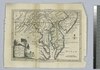
English: A map of Maryland with the Delaware counties and the southern part of New Jersey |
| Date | |
| Source | http://maps.nypl.org/warper/maps/13251 |
| Author | T. Kitchin |
| Other versions |
Licensing
|
This is a faithful photographic reproduction of a two-dimensional, public domain work of art. The work of art itself is in the public domain for the following reason:
The official position taken by the Wikimedia Foundation is that "faithful reproductions of two-dimensional public domain works of art are public domain".
This photographic reproduction is therefore also considered to be in the public domain in the United States. In other jurisdictions, re-use of this content may be restricted; see Reuse of PD-Art photographs for details. | ||||
File history
Click on a date/time to view the file as it appeared at that time.
| Date/Time | Thumbnail | Dimensions | User | Comment | |
|---|---|---|---|---|---|
| current | 03:04, 5 July 2021 |  | 2,373 × 1,796 (8.91 MB) | Zoozaz1 | File:A map of Maryland with the Delaware counties and the southern part of New Jersey.tif cropped 29 % horizontally, 23 % vertically using CropTool with precise mode. |
File usage
The following page uses this file:
Global file usage
The following other wikis use this file:
- Usage on en.wikipedia.org
- Usage on it.wikipedia.org
- Usage on uk.wikipedia.org