File:Africa in 400 BC.jpg
No higher resolution available.
Africa_in_400_BC.jpg (361 × 331 pixels, file size: 28 KB, MIME type: image/jpeg)
| This is a file from the Wikimedia Commons. Information from its description page there is shown below. Commons is a freely licensed media file repository. You can help. |
The lost tribe of Shabazz are the descendants of the Kingdom of Saba. They are a great tribe that descend from Queen Sheba & King Solomon. From this union the tribe of Shabazz descend from. Some African Americans come from this lineage. The lost Tribe of Shabazz is also known as (Bani Saba).
ref: (The lost Tribe of Shabazz.) written by Menelek As-Saba’i. Published in 2020
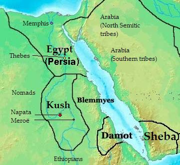
Summary: Map of Southern Arabia and East Africa (Sudan + Eygpt) 400 bc
| Description |
English: Map of kingdoms, states and tribes in 400 BC Africa.
Polski: Mapa królestw, państw i plemion w Afryce w 400 p.n.e.. |
| Date | |
| Source | Own work |
| Author | Kubek15 |
| Other versions |
 |
Licensing
I, the copyright holder of this work, hereby publish it under the following licenses:

|
Permission is granted to copy, distribute and/or modify this document under the terms of the GNU Free Documentation License, Version 1.2 or any later version published by the Free Software Foundation; with no Invariant Sections, no Front-Cover Texts, and no Back-Cover Texts. A copy of the license is included in the section entitled GNU Free Documentation License. |
This file is licensed under the Creative Commons Attribution-Share Alike 4.0 International, 3.0 Unported, 2.5 Generic, 2.0 Generic and 1.0 Generic license.
- You are free:
- to share – to copy, distribute and transmit the work
- to remix – to adapt the work
- Under the following conditions:
- attribution – You must give appropriate credit, provide a link to the license, and indicate if changes were made. You may do so in any reasonable manner, but not in any way that suggests the licensor endorses you or your use.
- share alike – If you remix, transform, or build upon the material, you must distribute your contributions under the same or compatible license as the original.
You may select the license of your choice.

|
This historical map image could be re-created using vector graphics as an SVG file. This has several advantages; see Commons:Media for cleanup for more information. If an SVG form of this image is available, please upload it and afterwards replace this template with
{{vector version available|new image name}}.
It is recommended to name the SVG file “Africa in 400 BC.svg”—then the template Vector version available (or Vva) does not need the new image name parameter. |


File history
Click on a date/time to view the file as it appeared at that time.
| Date/Time | Thumbnail | Dimensions | User | Comment | |
|---|---|---|---|---|---|
| current | 13:28, 17 July 2010 | | 361 × 331 (28 KB) | Kubek15 | {{Information |Description={{en|1=Map of kingdoms, states and tribes in 400 BC Africa.}} {{pl|1=Mapa królestw, państw i plemion w Afryce w 400 p.n.e..}} |Source={{own}} |Author=Kubek15 |Date=2010-07-17 |Per |
File usage
The following page uses this file:
Global file usage
The following other wikis use this file:
- Usage on ar.wikipedia.org
- Usage on arz.wikipedia.org
- Usage on ast.wikipedia.org
- Usage on az.wikipedia.org
- Usage on be.wikipedia.org
- Usage on bg.wikipedia.org
- Usage on br.wikipedia.org
- Usage on ca.wikipedia.org
- Usage on ce.wikipedia.org
- Usage on cs.wikipedia.org
- Usage on cv.wikipedia.org
- Usage on da.wikipedia.org
- Usage on el.wikipedia.org
- Usage on en.wikipedia.org
- Usage on en.wikibooks.org
- Usage on eu.wikipedia.org
- Usage on fa.wikipedia.org
- Usage on fi.wikipedia.org
- Usage on fr.wikipedia.org
- Usage on ha.wikipedia.org
- Usage on hr.wikipedia.org
- Usage on hu.wikipedia.org
- Usage on hy.wikipedia.org
- Usage on id.wikipedia.org
- Usage on it.wikipedia.org
- Usage on ja.wikipedia.org
- Usage on ka.wikipedia.org
- Usage on ko.wikipedia.org
- Usage on la.wikipedia.org
View more global usage of this file.