File:Ararat ast 2002176 lrg.jpg

Size of this preview: 800 × 486 pixels. Other resolutions: 320 × 194 pixels | 640 × 388 pixels | 1,160 × 704 pixels.
Original file (1,160 × 704 pixels, file size: 207 KB, MIME type: image/jpeg)
| This is a file from the Wikimedia Commons. Information from its description page there is shown below. Commons is a freely licensed media file repository. You can help. |
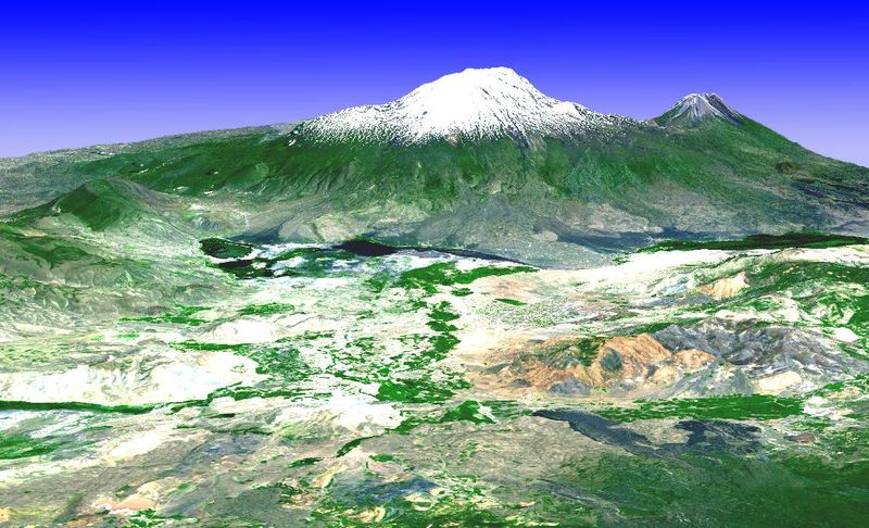
Mount Ararat, NASA
This image is a 3-D perspective view looking from the southwest, created by draping a simulated natural color image over an Advanced Spaceborne Thermal Emission and Reflection Radiometer (ASTER)-derived digital topography model. The image was acquired on June 25, 2002, and is located at 39.75 degrees North latitude, 44.4 degrees East longitude.
| This file is in the public domain in the United States because it was solely created by NASA. NASA copyright policy states that "NASA material is not protected by copyright unless noted". (See Template:PD-USGov, NASA copyright policy page or JPL Image Use Policy.) | ||
 |
Warnings:
|
File history
Click on a date/time to view the file as it appeared at that time.
| Date/Time | Thumbnail | Dimensions | User | Comment | |
|---|---|---|---|---|---|
| current | 23:23, 16 December 2004 | | 1,160 × 704 (207 KB) | Mschlindwein | Mount Ararat |
File usage
The following page uses this file:
Global file usage
The following other wikis use this file:
- Usage on cv.wikipedia.org
- Usage on cy.wikipedia.org
- Usage on de.wikipedia.org
- Usage on hy.wikipedia.org
- Usage on hyw.wikipedia.org
- Usage on ku.wikipedia.org
- Usage on sah.wikipedia.org