File:BattleforRome1944DiademPlan.svg

Size of this PNG preview of this SVG file: 800 × 374 pixels. Other resolutions: 320 × 150 pixels | 640 × 299 pixels | 1,024 × 478 pixels | 1,280 × 598 pixels | 2,560 × 1,196 pixels | 1,603 × 749 pixels.
Original file (SVG file, nominally 1,603 × 749 pixels, file size: 318 KB)
| This is a file from the Wikimedia Commons. Information from its description page there is shown below. Commons is a freely licensed media file repository. You can help. |
Summary
| Description |
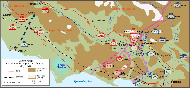
English: Sketchmap of Allied plan of attack in Italy (Operation Diadem), May 1944 |
| Date | |
| Source | Own work |
| Author | Kirrages |
| Other versions |
[]
|


Licensing
I, the copyright holder of this work, hereby publish it under the following licenses:
This file is licensed under the Creative Commons Attribution-Share Alike 3.0 Unported license.
- You are free:
- to share – to copy, distribute and transmit the work
- to remix – to adapt the work
- Under the following conditions:
- attribution – You must give appropriate credit, provide a link to the license, and indicate if changes were made. You may do so in any reasonable manner, but not in any way that suggests the licensor endorses you or your use.
- share alike – If you remix, transform, or build upon the material, you must distribute your contributions under the same or compatible license as the original.

|
Permission is granted to copy, distribute and/or modify this document under the terms of the GNU Free Documentation License, Version 1.2 or any later version published by the Free Software Foundation; with no Invariant Sections, no Front-Cover Texts, and no Back-Cover Texts. A copy of the license is included in the section entitled GNU Free Documentation License. |
You may select the license of your choice.
File history
Click on a date/time to view the file as it appeared at that time.
| Date/Time | Thumbnail | Dimensions | User | Comment | |
|---|---|---|---|---|---|
| current | 10:42, 11 November 2010 | | 1,603 × 749 (318 KB) | Kirrages | Mountain range names |
| 17:18, 10 November 2010 |  | 1,603 × 749 (316 KB) | Kirrages | Small tweaks | |
| 16:52, 10 November 2010 |  | 1,603 × 749 (315 KB) | Kirrages | Format railway, marshland &c | |
| 14:10, 10 November 2010 |  | 1,603 × 749 (227 KB) | Kirrages | Added defensive formations. Source: Clark, LLoyd (2006). Anzio: The Friction of War. Italy and the Battle for Rome 1944. Headline Publishing Group, London. ISBN 978 0 7553 1420 1. Molony, Brigadier C.J.C.; with Flynn, Captain F.C. (R.N.); Davies, Major-Ge | |
| 06:52, 10 November 2010 |  | 1,603 × 749 (171 KB) | Kirrages | Minor tweak | |
| 06:41, 10 November 2010 |  | 1,603 × 749 (171 KB) | Kirrages | Updating formats to match other maps | |
| 11:11, 26 September 2008 |  | 1,579 × 734 (141 KB) | Kirrages | Added Pontine Marshes etc | |
| 09:34, 26 September 2008 |  | 1,579 × 734 (137 KB) | Kirrages | Minor changes, colour balance etc | |
| 08:44, 26 September 2008 |  | 1,579 × 734 (134 KB) | Kirrages | Corrections to Fifth Army name and position of Hitler Line | |
| 10:59, 25 September 2008 |  | 1,579 × 734 (134 KB) | Kirrages | {{Information |Description={{en|1=Sketchmap of Allied plan of attack in Italy (Operation Diadem), May 1944}} |Source=Own work by uploader |Author=Kirrages |Date=2008-09-25 |Permission= |other_versions= }} <!--{{ImageUpload|full}}--> |
File usage
The following page uses this file:
Global file usage
The following other wikis use this file:
- Usage on azb.wikipedia.org
- Usage on be-tarask.wikipedia.org
- Usage on bg.wikipedia.org
- Usage on bs.wikipedia.org
- Usage on da.wikipedia.org
- Usage on de.wikipedia.org
- Usage on en.wikipedia.org
- Usage on es.wikipedia.org
- Usage on fi.wikipedia.org
- Usage on fr.wikipedia.org
- Usage on he.wikipedia.org
- Usage on hr.wikipedia.org
- Usage on it.wikipedia.org
- Usage on pt.wikipedia.org
- Usage on ro.wikipedia.org
- Usage on ru.wikipedia.org
- Usage on sh.wikipedia.org
- Usage on www.wikidata.org
- Usage on zh.wikipedia.org