File:Britonia6hcentury.png

Size of this preview: 342 × 600 pixels. Other resolutions: 137 × 240 pixels | 274 × 480 pixels | 438 × 768 pixels | 584 × 1,024 pixels | 1,670 × 2,928 pixels.
Original file (1,670 × 2,928 pixels, file size: 542 KB, MIME type: image/png)
| This is a file from the Wikimedia Commons. Information from its description page there is shown below. Commons is a freely licensed media file repository. You can help. |

|
File:Britonia6hcentury2.svg is a vector version of this file. It should be used in place of this PNG file when not inferior.
File:Britonia6hcentury.png → File:Britonia6hcentury2.svg
For more information, see Help:SVG. |
 |
References
- Young, Simon (2005) A.D. 500: A Journey through the Dark Isles of Britain and Ireland, Weidenfeld & Nicolson ISBN: 0297848054. - p.17 and map on p.15
Summary
| Description |
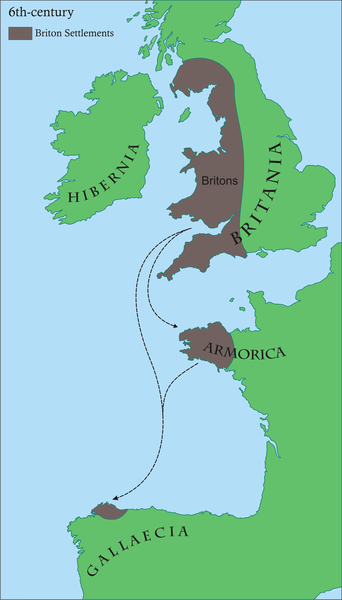
Français : Carte des régions d'Europe occidentale ayant des communautés Brythonic au 6ème siècle après JC
English: Map of areas in western Europe with Brythonic communities for the 6th century AD Galego: Mapa dos asentamentos britónicos no occidente europeo arredor do século VI da nosa era.
Os territorios aparecen en marrón, mentres o verde indica a situación xeográfica. |
| Date | |
| Source | Own work |
| Author | Rubén Tarrío |
| Permission (Reusing this file) |
own work |
Licensing
| I, the copyright holder of this work, release this work into the public domain. This applies worldwide. In some countries this may not be legally possible; if so: I grant anyone the right to use this work for any purpose, without any conditions, unless such conditions are required by law. |
File history
Click on a date/time to view the file as it appeared at that time.
| Date/Time | Thumbnail | Dimensions | User | Comment | |
|---|---|---|---|---|---|
| current | 08:45, 17 June 2008 | | 1,670 × 2,928 (542 KB) | Le Galicien | {{Information |Description={{gl|1=Mapa dos asentamentos britónicos no occidente europeo arredor do século VI da nosa era. Os territorios aparecen en marrón, mentres o verde indica a situación xeográfica.}} |Source=Own work by uploader |Author=Rubén |
File usage
The following page uses this file:
Global file usage
The following other wikis use this file:
- Usage on af.wikipedia.org
- Usage on als.wikipedia.org
- Usage on an.wikipedia.org
- Usage on arz.wikipedia.org
- Usage on ast.wikipedia.org
- Usage on azb.wikipedia.org
- Usage on be.wikipedia.org
- Usage on bg.wikipedia.org
- Usage on bn.wikipedia.org
- Usage on br.wikipedia.org
- Usage on ca.wikipedia.org
- Usage on cs.wikipedia.org
- Usage on cy.wikipedia.org
- Usage on el.wikipedia.org
- Usage on en.wikipedia.org
- 510
- Brittany
- Romano-British culture
- Armorica
- History of Brittany
- Celtic Britons
- History of Galicia
- Kingdom of the Suebi
- Bretons
- User talk:SPQRobin
- Timeline of Cornish history
- User talk:Chzz/Archive 11
- Wikipedia:Reference desk/Archives/Humanities/2011 April 29
- User:Ibonarzua/sandbox/Wikipedia improvement2
- User:Anuragngoel/Romano-British culture
- Usage on es.wikipedia.org
View more global usage of this file.