File:Burgess model.svg

Size of this PNG preview of this SVG file: 512 × 203 pixels. Other resolutions: 320 × 127 pixels | 640 × 254 pixels | 1,024 × 406 pixels | 1,280 × 508 pixels | 2,560 × 1,015 pixels.
Original file (SVG file, nominally 512 × 203 pixels, file size: 86 KB)
| This is a file from the Wikimedia Commons. Information from its description page there is shown below. Commons is a freely licensed media file repository. You can help. |
Summary
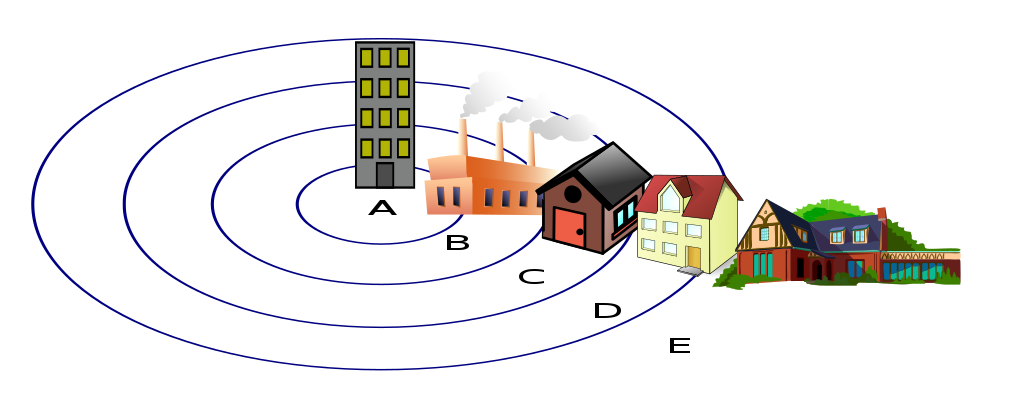
| Description | Diagram of the w:Concentric ring model of urban land use. |
| Date | 2 September 2006 (original upload date) |
| Source | No machine-readable source provided. Own work assumed (based on copyright claims). |
| Author | No machine-readable author provided. Zeimusu assumed (based on copyright claims). |
Key
A The Central Business District. B The Zone of Transition. C Inner city D Commuter zone E Countryside Area
Reference
Licensing
| I, the copyright holder of this work, release this work into the public domain. This applies worldwide. In some countries this may not be legally possible; if so: I grant anyone the right to use this work for any purpose, without any conditions, unless such conditions are required by law. |
File history
Click on a date/time to view the file as it appeared at that time.
| Date/Time | Thumbnail | Dimensions | User | Comment | |
|---|---|---|---|---|---|
| current | 16:20, 23 July 2022 | 512 × 203 (86 KB) | Smasongarrison | smaller using minifier // Editing SVG source code using c:User:Rillke/SVGedit.js | |
| 14:48, 2 September 2006 | 478 × 189 (176 KB) | Zeimusu | Diagram of the w:Concentric ring model of urban land use. ===Key=== A The Central Business Distict. B The Zone of Transition. C Working class residential D Commuter zone E Countryside area |
File usage
The following page uses this file:
Global file usage
The following other wikis use this file:
- Usage on ca.wikipedia.org
- Usage on ckb.wikipedia.org
- Usage on cs.wikipedia.org
- Usage on de.wikipedia.org
- Usage on en.wikipedia.org
- Usage on eu.wikipedia.org
- Usage on fi.wikipedia.org
- Usage on fr.wikipedia.org
- Usage on gl.wikipedia.org
- Usage on hu.wikipedia.org
- Usage on it.wikipedia.org
- Usage on ja.wikipedia.org
- Usage on nl.wikipedia.org
- Usage on no.wikipedia.org
- Usage on pl.wikipedia.org
- Usage on ru.wikipedia.org
- Usage on ru.wikibooks.org
- Usage on sv.wikipedia.org
- Usage on zh.wikipedia.org
- Usage on zh.wikibooks.org