File:Cape Verde location map Topographic.png

Size of this preview: 690 × 599 pixels. Other resolutions: 276 × 240 pixels | 553 × 480 pixels | 884 × 768 pixels | 1,179 × 1,024 pixels | 2,400 × 2,085 pixels.
Original file (2,400 × 2,085 pixels, file size: 1.28 MB, MIME type: image/png)
| This is a file from the Wikimedia Commons. Information from its description page there is shown below. Commons is a freely licensed media file repository. You can help. |
Summary
| Description |
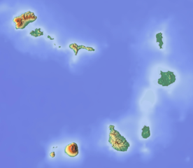
Deutsch: Positionskarte von Kap Verde.
Quadratische Plattkarte. Geographische Begrenzung der Karte:
English: Location map of Cape Verde.
Equirectangular projection. Geographic limits of the map:
|
| Date | |
| Source | Own work (backgroung : http://www.maps-for-free.com) |
| Author | Dr Brains |
Licensing
I, the copyright holder of this work, hereby publish it under the following licenses:

|
Permission is granted to copy, distribute and/or modify this document under the terms of the GNU Free Documentation License, Version 1.2 only as published by the Free Software Foundation; with no Invariant Sections, no Front-Cover Texts, and no Back-Cover Texts. A copy of the license is included in the section entitled GNU Free Documentation License. | 1.2 only |
|
|
Permission is granted to copy, distribute and/or modify this document under the terms of the GNU Free Documentation License, Version 1.3 or any later version published by the Free Software Foundation; with no Invariant Sections, no Front-Cover Texts, and no Back-Cover Texts. A copy of the license is included in the section entitled GNU Free Documentation License.
|
If this file is eligible for relicensing, it may also be used under the Creative Commons Attribution-ShareAlike 3.0 license. The relicensing status of this image needs to be manually reviewed by an experienced user. You can help.
|
You may select the license of your choice.
File history
Click on a date/time to view the file as it appeared at that time.
| Date/Time | Thumbnail | Dimensions | User | Comment | |
|---|---|---|---|---|---|
| current | 14:58, 15 June 2012 | | 2,400 × 2,085 (1.28 MB) | Dr Brains |
File usage
The following 9 pages use this file:
Global file usage
The following other wikis use this file:
- Usage on ar.wikipedia.org
- Usage on ast.wikipedia.org
- Usage on bh.wikipedia.org
- Usage on bn.wikipedia.org
- Usage on bs.wikipedia.org
- Usage on ca.wikipedia.org
- Usage on ceb.wikipedia.org
- Usage on de.wikivoyage.org
- Usage on el.wikipedia.org
- Usage on en.wikipedia.org
- Praia
- São Vicente, Cape Verde
- Maio, Cape Verde
- Fogo, Cape Verde
- Brava, Cape Verde
- Sal, Cape Verde
- Santo Antão, Cape Verde
- Santa Luzia, Cape Verde
- São Nicolau, Cape Verde
- Boa Vista, Cape Verde
- Santiago, Cape Verde
- Ilhéu Raso
- Ilhéu Branco
- Pico do Fogo
- Monte Cara
- Monte Verde (Cape Verde)
- Tope de Coroa
- Monte Gordo (Cape Verde)
- Monte Estância
- Monte Penoso
- Pico de Antónia
- Monte Bissau
- Pico de Alberto
- Madeiral
- Ilhéus do Rombo
- Ilhéu Grande
- Serra Malagueta
- Canal de São Vicente
- Ilhéu de Cima
- Ilhéu dos Pássaros
- Caixa (São Vicente)
View more global usage of this file.