File:Caucasiamapussr.gif
No higher resolution available.
Caucasiamapussr.gif (700 × 590 pixels, file size: 81 KB, MIME type: image/gif)
| This is a file from the Wikimedia Commons. Information from its description page there is shown below. Commons is a freely licensed media file repository. You can help. |

|
File:Soviet Caucasus map.svg is a vector version of this file. It should be used in place of this GIF file when not inferior.
File:Caucasiamapussr.gif → File:Soviet Caucasus map.svg
For more information, see Help:SVG. |
 |
Summary
| Description |
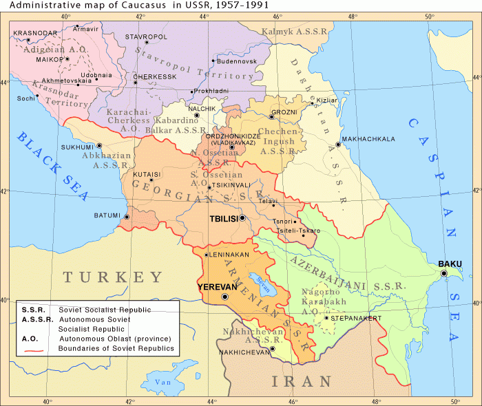
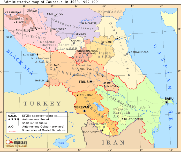
English: Administrative map of Caucasus in USSR, 1952-1991 |
| Date |
Uploaded to Armenica.org before 7 December 2006 (archived version)
|
| Source | Originally uploded from en.wikipedia; description page is/was here. |
| Author | www.armenica.org |
| Other versions | العربيَّة |
Licensing

|
Permission is granted to copy, distribute and/or modify this document under the terms of the GNU Free Documentation License, Version 1.2 or any later version published by the Free Software Foundation; with no Invariant Sections, no Front-Cover Texts, and no Back-Cover Texts. A copy of the license is included in the section entitled GNU Free Documentation License. |
This permission only applies to images existing on http://armenica.org/ as of 1 January 2007. Any later images do not fall under this permission!
Original upload log
(All user names refer to en.wikipedia)
- 2007-01-03 03:06 Artaxiad 700×590×6 (60613 bytes) Administrative map of [[Caucasus]] in USSR, 1952-1991 Source: Armenica.org [[Category:Armenica images]]
File history
Click on a date/time to view the file as it appeared at that time.
| Date/Time | Thumbnail | Dimensions | User | Comment | |
|---|---|---|---|---|---|
| current | 16:30, 10 May 2012 | | 700 × 590 (81 KB) | M0tty | Licence autorising modification → remove watermark |
| 20:03, 5 May 2012 |  | 700 × 591 (78 KB) | Geagea | Original map according to the OTRS permission. Not to be reverted. | |
| 04:49, 27 March 2011 |  | 700 × 590 (81 KB) | Hellerick | The earlier changes were correct. | |
| 19:12, 16 January 2011 |  | 700 × 590 (59 KB) | Geagea | Reverted to version as of 10:16, 24 February 2007. To the uploader's last version | |
| 18:38, 16 January 2011 |  | 700 × 590 (81 KB) | Nicolay Sidorov | Adygea to Krasnodar, Karachay-Cherkess to Stavropol. | |
| 18:31, 16 January 2011 |  | 700 × 590 (80 KB) | Nicolay Sidorov | The Chechen-Ingush republic was restored on January 9, 1957 | |
| 10:16, 24 February 2007 |  | 700 × 590 (59 KB) | Hardscarf | {{Information |Description=Administrative map of en:Caucasus in USSR, 1952-1991 |Source=Armenica.org {{ConfirmationImageOTRS|source=http://armenica.org/|otrs=2007010210006387}} Originally from [http://en.wikipedia.org en.wikipedia]; description page |
File usage
The following page uses this file:
Global file usage
The following other wikis use this file:
- Usage on ar.wikipedia.org
- Usage on azb.wikipedia.org
- Usage on az.wikipedia.org
- Usage on ca.wikipedia.org
- Usage on el.wikipedia.org
- Usage on en.wikipedia.org
- Usage on et.wikipedia.org
- Usage on fi.wikipedia.org
- Usage on fo.wikipedia.org
- Usage on he.wikipedia.org
- Usage on hi.wikipedia.org
- Usage on hr.wikipedia.org
- Usage on id.wikipedia.org
- Usage on is.wikipedia.org
- Usage on ja.wikipedia.org
- Usage on jv.wikipedia.org
- Usage on ko.wikipedia.org
- Usage on nn.wikipedia.org
- Usage on no.wikipedia.org
- Usage on pl.wiktionary.org
- Usage on ro.wikipedia.org
- Usage on ru.wikipedia.org
- Usage on so.wikipedia.org
View more global usage of this file.