File:Chesapeakewatershedmap.png

Size of this preview: 543 × 599 pixels. Other resolutions: 217 × 240 pixels | 435 × 480 pixels | 696 × 768 pixels | 927 × 1,024 pixels | 1,500 × 1,656 pixels.
Original file (1,500 × 1,656 pixels, file size: 2.79 MB, MIME type: image/png)
| This is a file from the Wikimedia Commons. Information from its description page there is shown below. Commons is a freely licensed media file repository. You can help. |
Summary
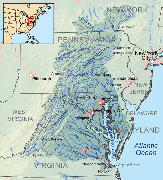
| Description | Map showing the Chesapeake Bay drainage basin. |
| Date | |
| Source | Own work, Elevation data from SRTM, hydrologic data from the National Hydrography Dataset, urban areas from Vector Map, all other features from the National Atlas. |
| Author | Kmusser |
Licensing
I, the copyright holder of this work, hereby publish it under the following license:
This file is licensed under the Creative Commons Attribution-Share Alike 3.0 Unported license.
- You are free:
- to share – to copy, distribute and transmit the work
- to remix – to adapt the work
- Under the following conditions:
- attribution – You must give appropriate credit, provide a link to the license, and indicate if changes were made. You may do so in any reasonable manner, but not in any way that suggests the licensor endorses you or your use.
- share alike – If you remix, transform, or build upon the material, you must distribute your contributions under the same or compatible license as the original.
File history
Click on a date/time to view the file as it appeared at that time.
| Date/Time | Thumbnail | Dimensions | User | Comment | |
|---|---|---|---|---|---|
| current | 16:54, 31 December 2010 | | 1,500 × 1,656 (2.79 MB) | Kmusser | == Summary == {{Information |Description=Map showing the Chesapeake Bay drainage basin. |Source={{own}}, Elevation data from SRTM, hydrologic data from the [[:w:National Hydrography Dataset|Nat |
File usage
The following page uses this file:
Global file usage
The following other wikis use this file:
- Usage on af.wikipedia.org
- Usage on ast.wikipedia.org
- Usage on ba.wikipedia.org
- Usage on be.wikipedia.org
- Usage on de.wikipedia.org
- Usage on en.wikipedia.org
- Usage on et.wikipedia.org
- Usage on fa.wikipedia.org
- Usage on fi.wikipedia.org
- Usage on frr.wikipedia.org
- Usage on he.wikipedia.org
- Usage on hu.wikipedia.org
- Usage on it.wikipedia.org
- Usage on ja.wikipedia.org
- Usage on la.wikipedia.org
- Usage on oc.wikipedia.org
- Usage on pl.wikipedia.org
- Usage on pms.wikipedia.org
- Usage on ru.wikipedia.org
- Usage on sh.wikipedia.org
- Usage on tr.wikipedia.org
- Usage on zh.wikipedia.org