File:Coal Tax Post no 151 - geograph.org.uk - 1151027.jpg

Size of this preview: 399 × 599 pixels. Other resolutions: 160 × 240 pixels | 426 × 640 pixels.
Original file (426 × 640 pixels, file size: 107 KB, MIME type: image/jpeg)
| This is a file from the Wikimedia Commons. Information from its description page there is shown below. Commons is a freely licensed media file repository. You can help. |
Summary
| Description |
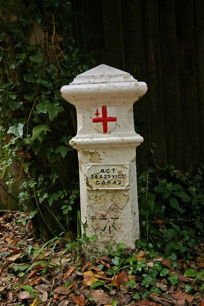
English: Coal Tax Post no 151. Coal Tax Posts were markers defining the area within which the Corporation of London could charge duty on coal and wine entering the area. This area had been expanded in 1851 and further expanded in 1861, and it is from the latter time that most of the existing posts date. See http://www.rhaworth.myby.co.uk/coalwine/postlist.htm for full list.
This is the southernmost and highest above sea level of all the Coal Tax Posts. See 1151030 for context. Note the benchmark (height = 214.7m). Grade II listed - for listing particulars see http://www.heritagegateway.org.uk/Gateway/Results_Single.aspx?uid=289580&resourceID=5 |
| Date | |
| Source | From geograph.org.uk |
| Author | Ian Capper |
| Attribution (required by the license) | Ian Capper / Coal Tax Post no 151 / |
| Camera location | | View this and other nearby images on: OpenStreetMap |
|---|
_heading:157.00&language=en)
| Object location | | View this and other nearby images on: OpenStreetMap |
|---|
_heading:157.00&language=en)
Licensing

|
This image was taken from the Geograph project collection. See this photograph's page on the Geograph website for the photographer's contact details. The copyright on this image is owned by Ian Capper and is licensed for reuse under the Creative Commons Attribution-ShareAlike 2.0 license.
|
This file is licensed under the Creative Commons Attribution-Share Alike 2.0 Generic license.
Attribution: Ian Capper
- You are free:
- to share – to copy, distribute and transmit the work
- to remix – to adapt the work
- Under the following conditions:
- attribution – You must give appropriate credit, provide a link to the license, and indicate if changes were made. You may do so in any reasonable manner, but not in any way that suggests the licensor endorses you or your use.
- share alike – If you remix, transform, or build upon the material, you must distribute your contributions under the same or compatible license as the original.
File history
Click on a date/time to view the file as it appeared at that time.
| Date/Time | Thumbnail | Dimensions | User | Comment | |
|---|---|---|---|---|---|
| current | 09:57, 25 February 2011 | | 426 × 640 (107 KB) | GeographBot | == {{int:filedesc}} == {{Information |description={{en|1=Coal Tax Post no 151 Coal Tax Posts were markers defining the area within which the Corporation of London could charge duty on coal and wine entering the area. This area had been expanded in 1851 a |
File usage
The following page uses this file:
Global file usage
The following other wikis use this file:
- Usage on sat.wikipedia.org