File:Contaminacion del Lago de Maracaibo.jpg
Size of this preview: 755 × 599 pixels. Other resolutions: 302 × 240 pixels | 605 × 480 pixels | 968 × 768 pixels | 1,280 × 1,016 pixels | 2,560 × 2,032 pixels | 5,015 × 3,981 pixels.
Original file (5,015 × 3,981 pixels, file size: 2.61 MB, MIME type: image/jpeg)
| This is a file from the Wikimedia Commons. Information from its description page there is shown below. Commons is a freely licensed media file repository. You can help. |
Summary
| Camera location | | View this and other nearby images on: OpenStreetMap |
|---|
| Description |
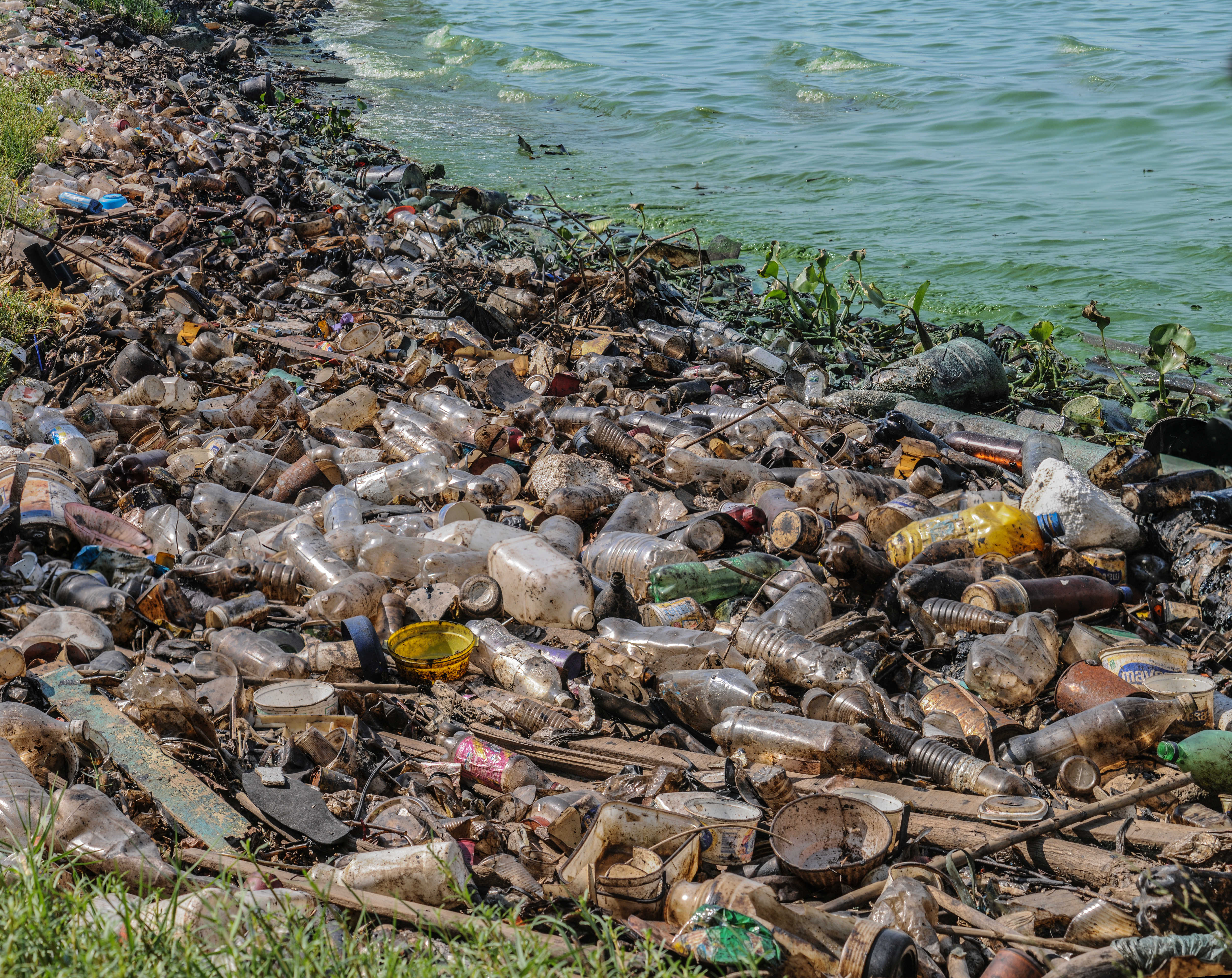
Español: El Lago de Maracaibo se encuentra ubicado en el Estado Zulia, Venezuela, es el lago mas grande de Sudamerica con un area de 13.820 km²[1], es común observar este tipo de contaminación a lo largo de todas sus costas contaminadas con lemmna sp, derrames de petroleo y desechos humanos son los principales contaminantes. Las actividades agrícolas, pecuarias, mineras e industriales, sin control, desarrolladas en la cuenca del Lago de Maracaibo, han originando un proceso acelerado de eutrofización en el mismo.[2]
English: Maracaibo Lake situated in Estado Zulia Venezuela is the biggest lake of South America with an area of 13820 km2[1], it is frequently to look this kind of pollution along of its coasts. It has lemna, oil spill, human waste as main pollutant. The uncontrolled agricultural activities, mining and industrial done in Maracaibo Lake Basin had started a rapid process of eutrophication on this place[2]. |
| Date | |
| Source | Own work |
| Author | Wilfredor |
References
- ↑ a b Maracaibo lake extension
- ↑ a b Eutrophication and Activities uncontrolled in Maracaibo lake extension

|
NOTE: This image is a panorama consisting of multiple frames that were merged or stitched in software. As a result, this image necessarily underwent some form of digital manipulation. These manipulations may include blending, blurring, cloning, and colour and perspective adjustments. As a result of these adjustments, the image content may be slightly different from reality at the points where multiple images were combined. This manipulation is often required due to lens, perspective, and parallax distortions.
|
Licensing
I, the copyright holder of this work, hereby publish it under the following license:
This file is licensed under the Creative Commons Attribution-Share Alike 3.0 Unported license.
- You are free:
- to share – to copy, distribute and transmit the work
- to remix – to adapt the work
- Under the following conditions:
- attribution – You must give appropriate credit, provide a link to the license, and indicate if changes were made. You may do so in any reasonable manner, but not in any way that suggests the licensor endorses you or your use.
- share alike – If you remix, transform, or build upon the material, you must distribute your contributions under the same or compatible license as the original.
This image has been assessed using the Quality image guidelines and is considered a Quality image.
|
File history
Click on a date/time to view the file as it appeared at that time.
| Date/Time | Thumbnail | Dimensions | User | Comment | |
|---|---|---|---|---|---|
| current | 09:20, 10 March 2015 | | 5,015 × 3,981 (2.61 MB) | RIMOLA | Better compression (without detail loss, non-progressive) |
| 05:49, 25 January 2013 |  | 5,015 × 3,981 (23.71 MB) | Slick-o-bot | Bot: convert to a non-interlaced jpeg (see bug #17645) | |
| 20:06, 9 September 2012 |  | 5,015 × 3,981 (20.79 MB) | Wilfredor | fix blur | |
| 15:57, 9 September 2012 |  | 5,015 × 3,981 (18.2 MB) | Wilfredor | more details | |
| 23:14, 8 September 2012 |  | 4,288 × 2,848 (8.39 MB) | Wilfredor | User created page with UploadWizard |
File usage
The following page uses this file:
Global file usage
The following other wikis use this file:
- Usage on ast.wikipedia.org
- Usage on bg.wikipedia.org
- Usage on ceb.wikipedia.org
- Usage on en.wikipedia.org
- Usage on es.wikipedia.org
- Usage on fr.wikipedia.org
- Usage on he.wikipedia.org
- Usage on sv.wikipedia.org
- Usage on vi.wikipedia.org