File:Eastern Front, 1914.jpg
Size of this preview: 774 × 599 pixels. Other resolutions: 310 × 240 pixels | 620 × 480 pixels | 891 × 690 pixels.
Original file (891 × 690 pixels, file size: 524 KB, MIME type: image/jpeg)
| This is a file from the Wikimedia Commons. Information from its description page there is shown below. Commons is a freely licensed media file repository. You can help. |

|
This military map image could be re-created using vector graphics as an SVG file. This has several advantages; see Commons:Media for cleanup for more information. If an SVG form of this image is available, please upload it and afterwards replace this template with
{{vector version available|new image name}}.
It is recommended to name the SVG file “Eastern Front, 1914.svg”—then the template Vector version available (or Vva) does not need the new image name parameter. |


Summary
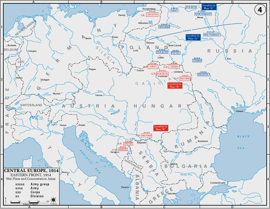
Map of the Eastern Front in World War 1, 1914.
From the History Department of the US Military Academy West Point - http://www.dean.usma.edu/history/web03/atlases/great%20war/great%20war%20index.htm archive copy at the Wayback Machine
Licensing
This work is in the public domain in the United States because it is a work prepared by an officer or employee of the United States Government as part of that person’s official duties under the terms of Title 17, Chapter 1, Section 105 of the US Code.
Note: This only applies to original works of the Federal Government and not to the work of any individual U.S. state, territory, commonwealth, county, municipality, or any other subdivision. This template also does not apply to postage stamp designs published by the United States Postal Service since 1978. (See § 313.6(C)(1) of Compendium of U.S. Copyright Office Practices). It also does not apply to certain US coins; see The US Mint Terms of Use.
|
 | |
| This file has been identified as being free of known restrictions under copyright law, including all related and neighboring rights. | ||
File history
Click on a date/time to view the file as it appeared at that time.
| Date/Time | Thumbnail | Dimensions | User | Comment | |
|---|---|---|---|---|---|
| current | 05:39, 9 January 2013 | | 891 × 690 (524 KB) | Poeticbent | Reverted to version as of 00:12, 9 January 2013. Probably a glitch in the system, because the new file does not show. |
| 00:21, 9 January 2013 |  | 891 × 690 (524 KB) | Poeticbent | not sure if I did it correctly | |
| 00:12, 9 January 2013 |  | 891 × 690 (524 KB) | Poeticbent | same source, same map, but already improved since last upload | |
| 10:18, 19 June 2006 |  | 1,241 × 961 (122 KB) | Yellowmellow45~commonswiki | Map of the Eastern Front in World War 2, 1914. From the History Department of the US Military Academy West Point - http://www.dean.usma.edu/history/web03/atlases/great%20war/great%20war%20i |
File usage
The following page uses this file:
Global file usage
The following other wikis use this file:
- Usage on ar.wikipedia.org
- Usage on az.wikipedia.org
- Usage on ba.wikipedia.org
- Usage on be.wikipedia.org
- Usage on bg.wikipedia.org
- Usage on ca.wikipedia.org
- Usage on da.wikipedia.org
- Usage on de.wikipedia.org
- Usage on en.wikipedia.org
- Usage on en.wikiversity.org
- Usage on es.wikipedia.org
- Usage on eu.wikipedia.org
- Usage on fi.wikipedia.org
- Usage on hu.wikipedia.org
- Usage on hy.wikipedia.org
- Usage on it.wikipedia.org
- Usage on ja.wikipedia.org
- Usage on mk.wikipedia.org
- Usage on mn.wikipedia.org
- Usage on nl.wikipedia.org
- Usage on nn.wikipedia.org
- Usage on no.wikipedia.org
- Usage on pl.wikipedia.org
- Usage on pnb.wikipedia.org
- Usage on ro.wikipedia.org
- Usage on sh.wikipedia.org
- Usage on sl.wikipedia.org
- Usage on sr.wikipedia.org
- Usage on sv.wikipedia.org
- Usage on tr.wikipedia.org
- Usage on uk.wikipedia.org
View more global usage of this file.