File:England 878.svg

Size of this PNG preview of this SVG file: 482 × 600 pixels. Other resolutions: 193 × 240 pixels | 386 × 480 pixels | 617 × 768 pixels | 823 × 1,024 pixels | 1,646 × 2,048 pixels | 988 × 1,229 pixels.
Original file (SVG file, nominally 988 × 1,229 pixels, file size: 1.54 MB)
| This is a file from the Wikimedia Commons. Information from its description page there is shown below. Commons is a freely licensed media file repository. You can help. |
Summary
| Description |
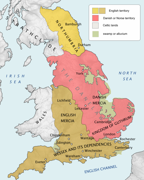
English: England and Wales at the time of the Treaty of Chippenham (AD 878) |
| Date | |
| Source |
Own work using:
|
| Author | Hel-hama |
| Other versions |
[]
|


.svg)


Licensing
I, the copyright holder of this work, hereby publish it under the following license:
This file is licensed under the Creative Commons Attribution-Share Alike 3.0 Unported license.
- You are free:
- to share – to copy, distribute and transmit the work
- to remix – to adapt the work
- Under the following conditions:
- attribution – You must give appropriate credit, provide a link to the license, and indicate if changes were made. You may do so in any reasonable manner, but not in any way that suggests the licensor endorses you or your use.
- share alike – If you remix, transform, or build upon the material, you must distribute your contributions under the same or compatible license as the original.
File history
Click on a date/time to view the file as it appeared at that time.
| Date/Time | Thumbnail | Dimensions | User | Comment | |
|---|---|---|---|---|---|
| current | 17:41, 14 August 2020 | | 988 × 1,229 (1.54 MB) | Rob984 | fixed typo |
| 21:18, 12 August 2020 |  | 988 × 1,229 (1.54 MB) | Þjarkur | Reverting Rob984's change because it included a typo. If someone can reinstate his edit without the typo, that would be ideal. | |
| 16:31, 9 December 2019 |  | 988 × 1,229 (1.54 MB) | Rob984 | "Northumberland" > "Northumbria". Not aware of usage of the modern-day's county's name in this historical context. | |
| 12:55, 22 May 2019 |  | 988 × 1,229 (1.54 MB) | Þjarkur | Make the colour of the area stand out more, the colours were too similar before to be able to discern | |
| 14:53, 8 July 2012 |  | 988 × 1,229 (1.54 MB) | Hel-hama | topography added | |
| 18:17, 13 June 2012 |  | 565 × 710 (432 KB) | Hel-hama | colours, borders | |
| 17:57, 13 June 2012 |  | 565 × 710 (425 KB) | Hel-hama | improved text | |
| 17:55, 13 June 2012 |  | 565 × 710 (282 KB) | Hel-hama |
File usage
The following page uses this file:
Global file usage
The following other wikis use this file:
- Usage on ar.wikipedia.org
- Usage on arz.wikipedia.org
- Usage on azb.wikipedia.org
- Usage on bg.wikipedia.org
- Usage on cs.wikipedia.org
- Usage on da.wikipedia.org
- Usage on el.wikipedia.org
- Usage on en.wikipedia.org
- History of England
- Wessex
- 878
- Northumbria
- Danelaw
- Bernicia
- Battle of Edington
- Æthelwold ætheling
- Northern England
- History of Anglo-Saxon England
- Portal:England
- A Gest of Robyn Hode
- Kingdom of East Anglia
- Viking expansion
- User:Dudley Miles/sandbox
- Wikipedia:Graphics Lab/Map workshop/Archive/Jan 2014
- English surnames of Norse origin
- Northumbria (modern)
- User:Alfielove14/sandbox
- History of monarchy in the United Kingdom
- Battle of Benfleet
- Government in Anglo-Saxon England
- Usage on en.wikiquote.org
- Usage on et.wikipedia.org
- Usage on eu.wikipedia.org
- Usage on fa.wikipedia.org
View more global usage of this file.