File:Gulf of Honduras.jpg

Size of this preview: 465 × 599 pixels. Other resolutions: 186 × 240 pixels | 372 × 480 pixels | 596 × 768 pixels | 795 × 1,024 pixels | 1,590 × 2,048 pixels | 2,602 × 3,352 pixels.
Original file (2,602 × 3,352 pixels, file size: 1.71 MB, MIME type: image/jpeg)
| This is a file from the Wikimedia Commons. Information from its description page there is shown below. Commons is a freely licensed media file repository. You can help. |
Summary
| Description |
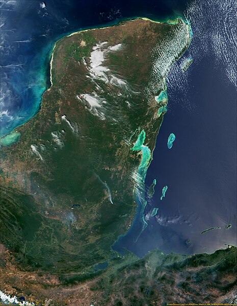
English: Yucatan Peninsula and Gulf of Honduras from MODIS - NASA Visible Earth. |
|||||
| Date | ||||||
| Source | http://visibleearth.nasa.gov/view.php?id=54567 | |||||
| Author | NASA | |||||
| Permission (Reusing this file) |
|
Licensing
| This file is in the public domain in the United States because it was solely created by NASA. NASA copyright policy states that "NASA material is not protected by copyright unless noted". (See Template:PD-USGov, NASA copyright policy page or JPL Image Use Policy.) | ||
 |
Warnings:
|
File history
Click on a date/time to view the file as it appeared at that time.
| Date/Time | Thumbnail | Dimensions | User | Comment | |
|---|---|---|---|---|---|
| current | 06:05, 3 January 2017 | | 2,602 × 3,352 (1.71 MB) | Timothy Gu | Better resolution |
| 22:56, 23 February 2009 |  | 1,302 × 1,677 (630 KB) | Arjuno3 | {{Information |Description={{en|1=Yucatan Peninsula and Gulf of Honduras from MODIS - NASA Visible Earth.}} |Source=http://veimages.gsfc.nasa.gov/292/MODIS1000085.jpg |Author=NASA |Date=2006-06-08 |Permission={{PD-USGov-NASA}} |other_versions= }} Gulf of |
File usage
The following page uses this file:
Global file usage
The following other wikis use this file:
- Usage on ar.wikipedia.org
- Usage on be.wikipedia.org
- Usage on bg.wikipedia.org
- Usage on ca.wikipedia.org
- Usage on ceb.wikipedia.org
- Usage on cs.wikipedia.org
- Usage on en.wikipedia.org
- Usage on eo.wikipedia.org
- Usage on es.wikipedia.org
- Usage on eu.wikipedia.org
- Usage on gl.wikipedia.org
- Usage on he.wikipedia.org
- Usage on it.wikipedia.org
- Usage on ka.wikipedia.org
- Usage on ko.wikipedia.org
- Usage on lt.wikipedia.org
- Usage on ml.wikipedia.org
- Usage on mt.wikipedia.org
- Usage on nds.wikipedia.org
- Usage on nl.wikipedia.org
- Usage on nn.wikipedia.org
- Usage on no.wikipedia.org
- Usage on pl.wikipedia.org
- Usage on pl.wiktionary.org
- Usage on pnb.wikipedia.org
- Usage on ru.wikipedia.org
- Usage on sk.wikipedia.org
- Usage on sl.wikipedia.org
- Usage on sv.wikipedia.org
- Usage on th.wikipedia.org
- Usage on tr.wikipedia.org
- Usage on uk.wikipedia.org
- Usage on ur.wikipedia.org
View more global usage of this file.