File:Gulf of Taranto map.png

Size of this preview: 545 × 600 pixels. Other resolutions: 218 × 240 pixels | 436 × 480 pixels | 698 × 768 pixels | 1,200 × 1,321 pixels.
Original file (1,200 × 1,321 pixels, file size: 348 KB, MIME type: image/png)
| This is a file from the Wikimedia Commons. Information from its description page there is shown below. Commons is a freely licensed media file repository. You can help. |
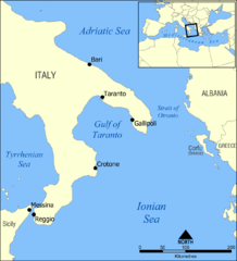
A map showing the location of the Gulf of Taranto in the Mediterranean sea, south of Italy.
Created by NormanEinstein, March 28, 2006.
I, the copyright holder of this work, hereby publish it under the following license:

|
Permission is granted to copy, distribute and/or modify this document under the terms of the GNU Free Documentation License, Version 1.2 or any later version published by the Free Software Foundation; with no Invariant Sections, no Front-Cover Texts, and no Back-Cover Texts. A copy of the license is included in the section entitled GNU Free Documentation License. |
| This file is licensed under the Creative Commons Attribution-Share Alike 3.0 Unported license. | ||
| ||
| This licensing tag was added to this file as part of the GFDL licensing update. |
Other versions
- Croatian: File:Gulf of Taranto map hr.svg
File history
Click on a date/time to view the file as it appeared at that time.
| Date/Time | Thumbnail | Dimensions | User | Comment | |
|---|---|---|---|---|---|
| current | 14:35, 3 June 2009 | | 1,200 × 1,321 (348 KB) | Rhegion | added Reggio |
| 18:53, 28 March 2006 |  | 1,200 × 1,321 (409 KB) | NormanEinstein | A map showing the location of the Gulf of Taranto in the Mediterranean sea, south of Italy. Created by NormanEinstein, March 28, 2006. {{GFDL-self}} |
File usage
The following page uses this file:
Global file usage
The following other wikis use this file:
- Usage on ar.wikipedia.org
- Usage on az.wikipedia.org
- Usage on ba.wikipedia.org
- Usage on be-tarask.wikipedia.org
- Usage on be.wikipedia.org
- Usage on br.wikipedia.org
- Usage on bs.wikipedia.org
- Usage on ckb.wikipedia.org
- Usage on cs.wikipedia.org
- Usage on da.wikipedia.org
- Usage on de.wikipedia.org
- Usage on de.wikibooks.org
- Usage on el.wikipedia.org
- Usage on en.wikipedia.org
- Tegetthoff-class battleship
- SMS Szent István
- Gulf of Taranto
- SMS Prinz Eugen (1912)
- User:NormanEinstein/gallery
- Adriatic campaign of 1807–1814
- Wikipedia:Graphics Lab/Map workshop/Archive/Feb 2012
- SMS Saida
- Yugoslav torpedo boat T4
- Novara-class cruiser
- SMS Tegetthoff (1912)
- SMS Admiral Spaun
- SMS Orjen
- Usage on eo.wikipedia.org
- Usage on es.wikipedia.org
- Usage on eu.wikipedia.org
- Usage on ext.wikipedia.org
- Usage on fa.wikipedia.org
- Usage on fi.wikipedia.org
- Usage on fo.wikipedia.org
- Usage on fr.wikipedia.org
- Usage on gl.wikipedia.org
View more global usage of this file.