File:Hôtel des Invalides, North View, Paris 7e 140402 1.jpg

Size of this preview: 800 × 301 pixels. Other resolutions: 320 × 120 pixels | 640 × 241 pixels | 1,024 × 386 pixels | 1,280 × 482 pixels | 2,560 × 964 pixels | 6,732 × 2,535 pixels.
Original file (6,732 × 2,535 pixels, file size: 5.89 MB, MIME type: image/jpeg)
| This is a file from the Wikimedia Commons. Information from its description page there is shown below. Commons is a freely licensed media file repository. You can help. |
Summary
| Description |
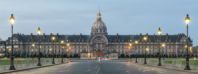
Deutsch: Nördliche Fassade des Hôtel des Invalides in der Abenddämmerung.
English: The north facade of the Hôtel des Invalides, seen at twilight
|
| Date | |
| Source | Own work |
| Author | DXR |
| Camera location | | View this and other nearby images on: OpenStreetMap |
|---|
|
Licensing
This file is licensed under the Creative Commons Attribution-Share Alike 3.0 Unported license.
Attribution: Daniel Vorndran / DXR
- You are free:
- to share – to copy, distribute and transmit the work
- to remix – to adapt the work
- Under the following conditions:
- attribution – You must give appropriate credit, provide a link to the license, and indicate if changes were made. You may do so in any reasonable manner, but not in any way that suggests the licensor endorses you or your use.
- share alike – If you remix, transform, or build upon the material, you must distribute your contributions under the same or compatible license as the original.
File history
Click on a date/time to view the file as it appeared at that time.
| Date/Time | Thumbnail | Dimensions | User | Comment | |
|---|---|---|---|---|---|
| current | 18:50, 16 April 2014 | 6,732 × 2,535 (5.89 MB) | DXR | Tilt fixed | |
| 22:32, 2 April 2014 | 6,732 × 2,535 (6.82 MB) | DXR | No light trails | ||
| 22:25, 2 April 2014 | 6,876 × 2,535 (6.37 MB) | DXR | VicuñaUploader 1.20 | ||
| 22:24, 2 April 2014 | 6,876 × 2,535 (6.37 MB) | DXR | VicuñaUploader 1.20 |
File usage
The following page uses this file:
Global file usage
The following other wikis use this file:
- Usage on ast.wikipedia.org
- Usage on cs.wikipedia.org
- Usage on de.wikipedia.org
- Usage on el.wikipedia.org
- Usage on en.wikipedia.org
- Les Invalides
- Talk:Les Invalides
- Portal:France
- Wikipedia:Featured pictures/Places/Panorama
- Wikipedia:WikiProject France
- User:Tomer T
- Wikipedia:WikiProject France/Article Status
- Wikipedia:WikiProject France/Featured and good content
- Wikipedia:WikiProject Historic sites
- User talk:DXR
- User talk:Tomer T/Archive 2
- Wikipedia:Featured pictures thumbs/43
- Wikipedia:Featured picture candidates/Les Invalides
- Wikipedia:Featured picture candidates/October-2014
- Wikipedia:Wikipedia Signpost/2014-10-15/Featured content
- Wikipedia:Wikipedia Signpost/Single/2014-10-15
- Wikipedia:Picture of the day/September 2016
- Paris ePrix
- Paris Street Circuit
- 2016 Paris ePrix
- Template:POTD/2016-09-29
- Wikipedia:Main Page history/2016 September 29
- Portal:Europe/Featured panorama
- Portal:Europe/Featured panorama/4
- 2017 Paris ePrix
- 2018 Paris ePrix
- Wikipedia:WikiProject Military history/Featured content
- Portal:The arts/Recognized content
- Portal:History/Recognized content
- Portal:Architecture/Recognized content
- Portal:France/Selected picture
- Usage on eo.wikipedia.org
- Usage on es.wikipedia.org
- Usage on eu.wikipedia.org
- Usage on fa.wikipedia.org
View more global usage of this file.