File:Haut-Ogooue departments.png

Size of this preview: 776 × 600 pixels. Other resolutions: 311 × 240 pixels | 621 × 480 pixels | 994 × 768 pixels | 1,056 × 816 pixels.
Original file (1,056 × 816 pixels, file size: 26 KB, MIME type: image/png)
| This is a file from the Wikimedia Commons. Information from its description page there is shown below. Commons is a freely licensed media file repository. You can help. |

|
This file requires updating. In doing so, you could add a timestamp to the file.
|
Summary
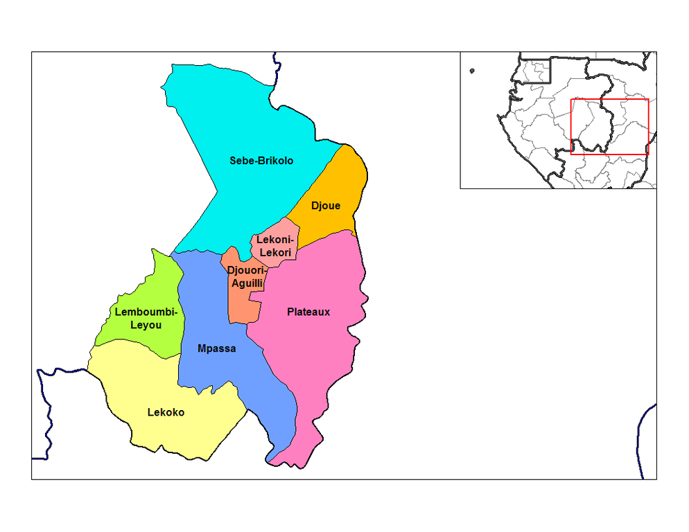
| Description | Map of the departments of Haut-Ogooue province in Gabon. Created by Rarelibra 20:20, 2 January 2007 (UTC) for public domain use, using MapInfo Professional v8.5 and various mapping resources. |
| Date | 2 January 2007 (original upload date) |
| Source | No machine-readable source provided. Own work assumed (based on copyright claims). |
| Author | No machine-readable author provided. Rarelibra assumed (based on copyright claims). |
Licensing
| I, the copyright holder of this work, release this work into the public domain. This applies worldwide. In some countries this may not be legally possible; if so: I grant anyone the right to use this work for any purpose, without any conditions, unless such conditions are required by law. |
File history
Click on a date/time to view the file as it appeared at that time.
| Date/Time | Thumbnail | Dimensions | User | Comment | |
|---|---|---|---|---|---|
| current | 20:20, 2 January 2007 | | 1,056 × 816 (26 KB) | Rarelibra | Map of the departments of Haut-Ogooue province in Gabon. Created by ~~~~ for public domain use, using MapInfo Professional v8.5 and various mapping resources. |
File usage
The following page uses this file:
Global file usage
The following other wikis use this file:
- Usage on avk.wikipedia.org
- Usage on ca.wikipedia.org
- Usage on cs.wikipedia.org
- Usage on en.wikipedia.org
- Usage on es.wikipedia.org
- Usage on fi.wikipedia.org
- Usage on ha.wikipedia.org
- Usage on ig.wikipedia.org
- Usage on it.wikipedia.org
- Usage on la.wikipedia.org
- Usage on mk.wikipedia.org
- Usage on nl.wikipedia.org
- Usage on pl.wikipedia.org
- Usage on pt.wikipedia.org
- Usage on ro.wikipedia.org
- Usage on ru.wikipedia.org
- Usage on sw.wikipedia.org
- Usage on tr.wikipedia.org
- Usage on ts.wikipedia.org
- Usage on uk.wikipedia.org
- Usage on vi.wikipedia.org
- Usage on www.wikidata.org
- Usage on yo.wikipedia.org
View more global usage of this file.