File:Hurricane Fabian 02 sept 2003.jpg

Size of this preview: 458 × 599 pixels. Other resolutions: 183 × 240 pixels | 367 × 480 pixels | 587 × 768 pixels | 783 × 1,024 pixels | 1,566 × 2,048 pixels | 5,200 × 6,800 pixels.
Original file (5,200 × 6,800 pixels, file size: 5.19 MB, MIME type: image/jpeg)
| This is a file from the Wikimedia Commons. Information from its description page there is shown below. Commons is a freely licensed media file repository. You can help. |
Summary
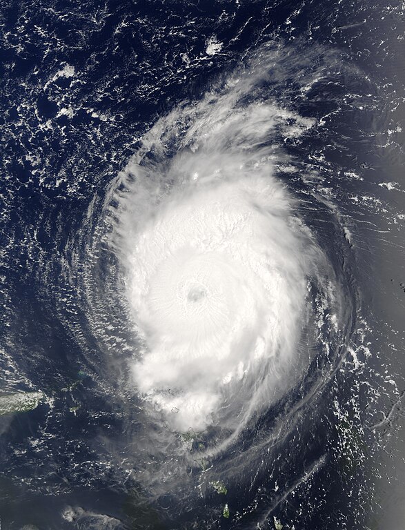
| Description | The MODIS instrument onboard NASA's Terra spacecraft captured this bird's-eye view of Hurricane Fabian in the Atlantic Ocean. In this image Fabian is located about 190 miles north-northeast of Barbuda in the northern Leeward Islands. Fabian is a Category 4 storm on the Saffir-Simpson Scale and is packing sustained winds of 140 mph with higher gusts. The National Hurricane Center expects Fabian to continue on a west-northwest path at 10 mph for the next 24 hours. | |||||
| Date | ||||||
| Source | http://visibleearth.nasa.gov/view_rec.php?id=5736 | |||||
| Author | Jacques Descloitres, MODIS Rapid Response Team, NASA/GSFC | |||||
| Permission (Reusing this file) |
|
|||||
| Other versions | Image:Hurricane fabian 2003.jpg |

File history
Click on a date/time to view the file as it appeared at that time.
| Date/Time | Thumbnail | Dimensions | User | Comment | |
|---|---|---|---|---|---|
| current | 15:45, 29 September 2006 | | 5,200 × 6,800 (5.19 MB) | Good kitty | == Summary == {{Information |Description=The MODIS instrument onboard NASA's Terra spacecraft captured this bird's-eye view of Hurricane Fabian in the Atlantic Ocean. In this image Fabian is located about 190 miles north-northeast of Barbuda in the northe |
File usage
The following 2 pages use this file:
Global file usage
The following other wikis use this file:
- Usage on ca.wikipedia.org
- Usage on en.wikipedia.org
- Usage on eo.wikipedia.org
- Usage on fr.wikipedia.org
- Usage on tl.wikipedia.org
- Usage on www.wikidata.org
- Usage on zh.wikipedia.org