File:Interstate 74 map.png

Size of this preview: 800 × 450 pixels. Other resolutions: 320 × 180 pixels | 640 × 360 pixels | 1,024 × 575 pixels | 1,280 × 719 pixels | 2,205 × 1,239 pixels.
Original file (2,205 × 1,239 pixels, file size: 94 KB, MIME type: image/png)
| This is a file from the Wikimedia Commons. Information from its description page there is shown below. Commons is a freely licensed media file repository. You can help. |
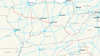
| Description | Map of Interstate 74 |
| Date | |
| Source | Own work |
| Author | Nick Nolte |
| Permission (Reusing this file) |
Own work, all rights released (Public domain) |
I, the copyright holder of this work, hereby publish it under the following license:
| This file is made available under the Creative Commons CC0 1.0 Universal Public Domain Dedication. | |
| The person who associated a work with this deed has dedicated the work to the public domain by waiving all of their rights to the work worldwide under copyright law, including all related and neighboring rights, to the extent allowed by law. You can copy, modify, distribute and perform the work, even for commercial purposes, all without asking permission.
|
File history
Click on a date/time to view the file as it appeared at that time.
| Date/Time | Thumbnail | Dimensions | User | Comment | |
|---|---|---|---|---|---|
| current | 17:14, 24 June 2017 | | 2,205 × 1,239 (94 KB) | Roadsguy | Updated to include current progress between Ellerbe and Winston-Salem, as well as more accurate routing of the proposed section along US 52 and the future Winston-Salem Northern Beltway. |
| 05:45, 11 December 2008 |  | 2,205 × 1,239 (155 KB) | MPD01605~commonswiki | Updated to include new sections of I-74 in North Carolina, also added pink shading for future route except in Ohio, as I could not find anything to solifify that route. | |
| 05:15, 16 July 2006 |  | 2,205 × 1,239 (159 KB) | Stratosphere | {{Information| |Description=Map of Interstate 74 |Source=Own Work |Date=July 15, 2006 |Author=Nick Nolte |Permission=Own work, all rights released (Public domain) |other_versions= }} {{PD-self}} Category:U.S. Interstate Maps[ |
File usage
There are no pages that use this file.
Global file usage
The following other wikis use this file:
- Usage on de.wikipedia.org
- Usage on eu.wikipedia.org
- Usage on fa.wikipedia.org
- Usage on fr.wikipedia.org
- Usage on ko.wikipedia.org
- Usage on lmo.wikipedia.org
- Usage on nl.wikipedia.org
- Usage on ru.wikipedia.org
- Usage on sv.wikipedia.org
- Usage on vi.wikipedia.org
- Usage on www.wikidata.org
- Usage on zh.wikipedia.org