File:KQA-b.jpg
No higher resolution available.
KQA-b.jpg (313 × 327 pixels, file size: 36 KB, MIME type: image/jpeg)
| This is a file from the Wikimedia Commons. Information from its description page there is shown below. Commons is a freely licensed media file repository. You can help. |
Summary
| Description |
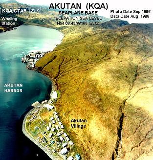
English: Annotated aerial photograph of Akutan Seaplane Base (KQA) in Akutan, Alaska, United States. |
| Date | Photo: September 1996, Data: August 1998 |
| Source |
|
| Author | Federal Aviation Administration, Alaskan Region |
| Permission (Reusing this file) |
Public domain |
| Object location | | View this and other nearby images on: OpenStreetMap |
|---|
Licensing
This image or file is a work of a Federal Aviation Administration employee, taken or made as part of that person's official duties. As a work of the U.S. federal government, the image is in the public domain in the United States.
|
 |
Original upload log
The original description page was here. All following user names refer to en.wikipedia.
- 2005-10-26 20:15 Zyxw 313×327× (37065 bytes) Photograph of Akutan Seaplane Base (KQA) http://www.alaska.faa.gov/fai/images/AKPEN/KQA-b.jpg
File history
Click on a date/time to view the file as it appeared at that time.
| Date/Time | Thumbnail | Dimensions | User | Comment | |
|---|---|---|---|---|---|
| current | 03:30, 21 August 2009 | | 313 × 327 (36 KB) | Lazyhawk | {{Information |Description={{en|Aerial photo of en:Akutan Seaplane Base (KQA) in Akutan, Alaska, United States. http://www.alaska.faa.gov/fai/airports.htm http://www.alaska.faa.gov/fai/images/AKPEN/KQA-b.jpg [[:en:Category:Federal Aviation Ad |
File usage
The following page uses this file:
Global file usage
The following other wikis use this file:
- Usage on ar.wikipedia.org
- Usage on arz.wikipedia.org
- Usage on azb.wikipedia.org
- Usage on ceb.wikipedia.org
- Usage on en.wikipedia.org
- Usage on fa.wikipedia.org
- Usage on it.wikipedia.org
- Usage on mg.wikipedia.org
- Usage on ml.wikipedia.org
- Usage on ru.wikipedia.org
- Usage on sh.wikipedia.org
- Usage on sr.wikipedia.org
- Usage on tg.wikipedia.org
- Usage on uz.wikipedia.org
- Usage on www.wikidata.org