File:Lakebalkhashbasinmap.png

Size of this preview: 800 × 546 pixels. Other resolutions: 320 × 218 pixels | 640 × 437 pixels | 1,024 × 698 pixels | 1,466 × 1,000 pixels.
Original file (1,466 × 1,000 pixels, file size: 1.52 MB, MIME type: image/png)
| This is a file from the Wikimedia Commons. Information from its description page there is shown below. Commons is a freely licensed media file repository. You can help. |
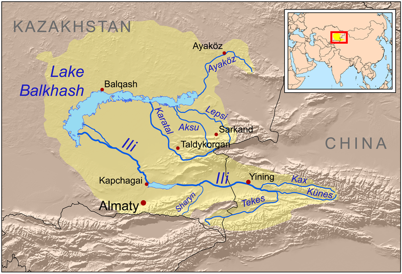
| Description | This is a map of the Lake Balkhash drainage basin, including the Ili River and its tributaries. |
| Date | |
| Source | Own work using Digital Chart of the World and GTOPO data, labels based on GEOnet. UNEP and Decrease of river runoff in the Lake Balkhash basin in Central Asia by Kader Kezer and Hiroshi Matsuyama used as references. |
| Author | Kmusser |
| Other versions | Magyar svg |
I, the copyright holder of this work, hereby publish it under the following license:
This file is licensed under the Creative Commons Attribution-Share Alike 3.0 Unported license.
- You are free:
- to share – to copy, distribute and transmit the work
- to remix – to adapt the work
- Under the following conditions:
- attribution – You must give appropriate credit, provide a link to the license, and indicate if changes were made. You may do so in any reasonable manner, but not in any way that suggests the licensor endorses you or your use.
- share alike – If you remix, transform, or build upon the material, you must distribute your contributions under the same or compatible license as the original.
File history
Click on a date/time to view the file as it appeared at that time.
| Date/Time | Thumbnail | Dimensions | User | Comment | |
|---|---|---|---|---|---|
| current | 21:01, 22 December 2008 | | 1,466 × 1,000 (1.52 MB) | Kmusser | {{Information |Description=This is a map of the Lake Balkhash drainage basin, including the Ili River and its tributaries. |Source=Own work using http://www.maproom.psu.edu/dcw/ Digital Chart of the World and [ |
File usage
The following page uses this file:
Global file usage
The following other wikis use this file:
- Usage on af.wikipedia.org
- Usage on ar.wikipedia.org
- Usage on arz.wikipedia.org
- Usage on ast.wikipedia.org
- Usage on azb.wikipedia.org
- Usage on az.wikipedia.org
- Usage on ba.wikipedia.org
- Usage on bg.wikipedia.org
- Usage on bn.wikipedia.org
- Usage on bs.wikipedia.org
- Usage on ca.wikipedia.org
- Usage on cs.wikipedia.org
- Usage on da.wikipedia.org
- Usage on de.wikipedia.org
- Usage on el.wikipedia.org
- Usage on en.wikipedia.org
View more global usage of this file.