File:MTR multiple cross platform interchange.svg

Size of this PNG preview of this SVG file: 750 × 500 pixels. Other resolutions: 320 × 213 pixels | 640 × 427 pixels | 1,024 × 683 pixels | 1,280 × 853 pixels | 2,560 × 1,707 pixels.
Original file (SVG file, nominally 750 × 500 pixels, file size: 11 KB)
| This is a file from the Wikimedia Commons. Information from its description page there is shown below. Commons is a freely licensed media file repository. You can help. |
Summary
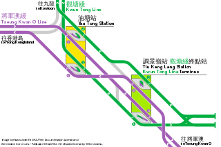
| Description | The multiple cross-platform-interchange system between Tiu Keng Leng and Yau Tong stations. Track alignment is heavily simplified and arbitrary compared to reality. For a geographically accurate map of the region around these 2 stations, please view this map. | |||
| Date | 23 October 2006 (original upload date); SVG rework: 9 June 2016 | |||
| Source | Self-published | |||
| Author | Sameboat | |||
| Other versions |
|


This vector image was created with a text editor.
Please do not replace the simplified code of this file with a version created with Inkscape or any other vector graphics editor
Licensing
I, the copyright holder of this work, hereby publish it under the following licenses:

|
Permission is granted to copy, distribute and/or modify this document under the terms of the GNU Free Documentation License, Version 1.2 or any later version published by the Free Software Foundation; with no Invariant Sections, no Front-Cover Texts, and no Back-Cover Texts. A copy of the license is included in the section entitled GNU Free Documentation License. |
| This file is licensed under the Creative Commons Attribution-Share Alike 3.0 Unported license. | ||
| ||
| This licensing tag was added to this file as part of the GFDL licensing update. |
You may select the license of your choice.
File history
Click on a date/time to view the file as it appeared at that time.
| Date/Time | Thumbnail | Dimensions | User | Comment | |
|---|---|---|---|---|---|
| current | 15:04, 15 July 2018 | | 750 × 500 (11 KB) | Sameboat | doctype |
| 09:50, 10 June 2016 |  | 750 × 500 (11 KB) | Jc86035 | changed — to – | |
| 09:39, 10 June 2016 |  | 750 × 500 (11 KB) | Jc86035 | added extra label for consistency | |
| 08:54, 10 June 2016 |  | 750 × 500 (10 KB) | Jc86035 | (m) fixed platform number offset | |
| 15:09, 9 June 2016 |  | 750 × 500 (11 KB) | Jc86035 | testing PNG rendering (numbers don't always align with circles) | |
| 15:01, 9 June 2016 |  | 750 × 500 (11 KB) | Jc86035 | put KTL southbound above TKL southbound south of Tiu Keng Leng; added title text for sidings; stylised platform numbers | |
| 09:40, 9 June 2016 |  | 750 × 500 (10 KB) | Sameboat | minor | |
| 08:06, 9 June 2016 |  | 750 × 500 (10 KB) | Sameboat | == {{int:filedesc}} == {{Information |description = The multiple cross-platform-interchange system between Tiu Keng Leng and Yau Tong stations. For a geographically accurate map of the region around these 2 stations, please view [[:image:TKL_ga_map.pn... |
File usage
The following page uses this file:
Global file usage
The following other wikis use this file:
- Usage on bg.wikipedia.org
- Usage on en.wikipedia.org
- Usage on ja.wikipedia.org
- Usage on ko.wikipedia.org
- Usage on nl.wikipedia.org
- Usage on pt.wikipedia.org
- Usage on ru.wikipedia.org
- Usage on zh-yue.wikipedia.org
- Usage on zh.wikipedia.org