File:Major Indo-Aryan languages.png
No higher resolution available.
Major_Indo-Aryan_languages.png (572 × 599 pixels, file size: 303 KB, MIME type: image/png)
| This is a file from the Wikimedia Commons. Information from its description page there is shown below. Commons is a freely licensed media file repository. You can help. |
Summary
| Description |
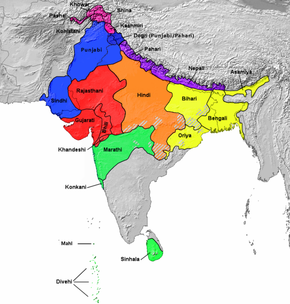
Français : Aires de répartition des principales langues indo-aryennes (carte de 1978). L'ourdou n'est pas représenté séparément du hindi. English: 1978 map showing Geographical distribution of the major Indo-Aryan languages. The western part is Proto-Indo-Europeans[1] (not shown in this map) including Medes, Persians, and Parthians [2] and Eastern Part (Urdu is included under Hindi. Romani, Domari, and Lomavren are outside the scope of the map.) Dotted/striped areas indicate where multilingualism is common.
|
||
| Date | |||
| Source | https://upload.wikimedia.org/wikipedia/commons/archive/0/0f/20151007205526!Indoarische_Sprachen_Gruppen.png | ||
| Author | Filpro | ||
| Other versions |
This file was derived from: Indoarische Sprachen Gruppen.png
|

Licensing
This file is licensed under the Creative Commons Attribution 3.0 Unported license.
- You are free:
- to share – to copy, distribute and transmit the work
- to remix – to adapt the work
- Under the following conditions:
- attribution – You must give appropriate credit, provide a link to the license, and indicate if changes were made. You may do so in any reasonable manner, but not in any way that suggests the licensor endorses you or your use.
- ↑ https://en.wikipedia.org/wiki/Proto-Indo-Iranian_language
- ↑ https://en.wikipedia.org/wiki/History_of_Iran#Early_Iron_Age
File history
Click on a date/time to view the file as it appeared at that time.
| Date/Time | Thumbnail | Dimensions | User | Comment | |
|---|---|---|---|---|---|
| current | 07:12, 28 July 2023 | | 572 × 599 (303 KB) | PadFoot2008 | |
| 08:41, 27 July 2023 |  | 572 × 599 (303 KB) | PadFoot2008 | Corrected lines based on correct linguistic classifications instead of social ones. | |
| 04:40, 20 September 2022 |  | 572 × 599 (307 KB) | Zhamidz | Reverted to version as of 16:55, 27 February 2018 (UTC). The map is different | |
| 09:47, 17 September 2021 |  | 500 × 500 (75 KB) | Amritsvāraya | changed the map into a more accurate map | |
| 16:55, 27 February 2018 |  | 572 × 599 (307 KB) | Mr rnddude | Bihari isn't a subset of the Hindi languages. Maithili is a language in its own right. | |
| 00:45, 29 October 2017 |  | 877 × 919 (583 KB) | फ़िलप्रो | Reverted to version as of 04:41, 6 June 2016 (UTC) Updated map will be a separate image. | |
| 05:25, 27 October 2017 |  | 877 × 919 (594 KB) | फ़िलप्रो | Updated boundaries based off of Ethnologue, Central-Eastern and Central-Western borders changed. Fixed unnamed region between Kashmiri, Dogri, and Pahari. | |
| 04:41, 6 June 2016 |  | 877 × 919 (583 KB) | फ़िलप्रो | Southern Zone | |
| 04:24, 6 June 2016 |  | 877 × 919 (580 KB) | फ़िलप्रो | Clean up. Corrections. | |
| 03:29, 12 January 2016 |  | 877 × 919 (573 KB) | फ़िलप्रो | colours and specified groupings |
File usage
There are no pages that use this file.
Global file usage
The following other wikis use this file:
- Usage on af.wikipedia.org
- Usage on as.wikipedia.org
- Usage on azb.wikipedia.org
- Usage on az.wikipedia.org
- Usage on ban.wikipedia.org
- Usage on bh.wikipedia.org
- Usage on bn.wikipedia.org
- Usage on bs.wikipedia.org
- Usage on da.wikipedia.org
- Usage on en.wikipedia.org
- Bhil languages
- Khas people
- Goaria language
- Malvi language
- Judeo-Marathi
- Dramatic Prakrit
- Shauraseni Prakrit
- Pardhi language
- Vlax Romani language
- Gamit language
- Danwar language
- Romani language standardization
- Brajavali dialect
- South Asian ethnic groups
- Shekhawati language
- Luwati language
- Ushoji language
- Dhundari language
- Abahattha
- Pashayi languages
- Shumashti language
- Sanskritism
- Sansi language
- Welsh Romani language
- Halbi language
- Kharia Thar language
- Nahari language
- Nangalami language
- Lubanki dialect
- Brokskat
- Old Hindi
- Finnish Kalo language
- Vasavi language
- Chit (consciousness)
- Tatparya
- Kadodi language
- Andh language
View more global usage of this file.