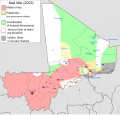
File:MaliWar.svg

Size of this PNG preview of this SVG file: 629 × 600 pixels. Other resolutions: 252 × 240 pixels | 503 × 480 pixels | 805 × 768 pixels | 1,074 × 1,024 pixels | 2,147 × 2,048 pixels | 1,644 × 1,568 pixels.
Original file (SVG file, nominally 1,644 × 1,568 pixels, file size: 861 KB)
File history
Click on a date/time to view the file as it appeared at that time.
| Date/Time | Thumbnail | Dimensions | User | Comment | |
|---|---|---|---|---|---|
| current | 01:41, 12 January 2024 |  | 1,644 × 1,568 (861 KB) | Clyde H. Mapping | 2023 → 2024 |
| 04:26, 4 January 2024 |  | 1,644 × 1,568 (861 KB) | Clyde H. Mapping | Updated Kidal and Aguelhok | |
| 17:23, 14 November 2023 |  | 1,644 × 1,568 (861 KB) | Wario2 | Updated as of November 14th, recent developments, such as the recapture of Anefif and Ménaka by the government, the ongoing battle of Kidal city, and the JNIM reconquest of Talataye. | |
| 03:18, 10 October 2023 |  | 1,644 × 1,568 (860 KB) | Clyde H. Mapping | Updated per template, added "allies" to "Malian Army" as Burkinabe territory is also represented | |
| 12:08, 15 September 2023 |  | 1,644 × 1,568 (852 KB) | KajenCAT | File uploaded using svgtranslate tool (https://svgtranslate.toolforge.org/). Added translation for ca. | |
| 19:27, 11 September 2023 |  | 1,644 × 1,568 (844 KB) | Borysk5 | From template | |
| 09:59, 5 August 2023 |  | 1,644 × 1,568 (477 KB) | Clyde H. Mapping | Update to Talataye per template | |
| 02:35, 19 April 2023 |  | 1,644 × 1,568 (476 KB) | Clyde H. Mapping | Update per template | |
| 04:49, 12 April 2023 |  | 1,644 × 1,568 (476 KB) | Clyde H. Mapping | Updates to Tidermène, Talataye, and Tin-n-Fadimata per template | |
| 04:15, 19 October 2022 |  | 1,644 × 1,568 (472 KB) | Clyde H. Mapping | Ansongo captured by ISIS |
File usage
The following page uses this file:
Global file usage
The following other wikis use this file:
- Usage on ar.wikipedia.org
- Usage on bm.wikipedia.org
- Usage on bn.wikipedia.org
- Usage on ca.wikipedia.org
- Usage on cs.wikipedia.org
- Usage on el.wikipedia.org
- Usage on en.wikipedia.org
- Usage on es.wikipedia.org
- Usage on fa.wikipedia.org
- Usage on fr.wikipedia.org
- Usage on he.wikipedia.org
- Usage on hu.wikipedia.org
- Usage on it.wikipedia.org
- Usage on ja.wikipedia.org
- Usage on ko.wikipedia.org
- Usage on pnb.wikipedia.org
- Usage on pt.wikipedia.org
- Usage on si.wikipedia.org
- Usage on so.wikipedia.org
- Usage on sr.wikipedia.org
- Usage on uk.wikipedia.org
- Usage on ur.wikipedia.org
- Usage on vi.wikipedia.org
- Usage on wa.wikipedia.org
- Usage on www.wikidata.org
- Usage on zh.wikipedia.org

