File:Map-Francophonie organisation en.svg

Size of this PNG preview of this SVG file: 800 × 353 pixels. Other resolutions: 320 × 141 pixels | 640 × 283 pixels | 1,024 × 452 pixels | 1,280 × 565 pixels | 2,560 × 1,131 pixels | 1,003 × 443 pixels.
Original file (SVG file, nominally 1,003 × 443 pixels, file size: 1.44 MB)
| This is a file from the Wikimedia Commons. Information from its description page there is shown below. Commons is a freely licensed media file repository. You can help. |
Summary
| Description |
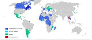
English: Map of the International Organisation of the Francophonie
Français : Carte de l'Organisation internationale de la Francophonie
日本語: フランコフォニー国際機関の加盟国と関連する国 |
| Date | |
| Source | File:Map-Francophonie organisation fr.svg |
| Author | Bourrichon; derivative work Giorgi Balakhadze |
| Other versions |
|


Licensing
| I, the copyright holder of this work, release this work into the public domain. This applies worldwide. In some countries this may not be legally possible; if so: I grant anyone the right to use this work for any purpose, without any conditions, unless such conditions are required by law. |
File history
Click on a date/time to view the file as it appeared at that time.
| Date/Time | Thumbnail | Dimensions | User | Comment | |
|---|---|---|---|---|---|
| current | 00:52, 21 September 2019 | | 1,003 × 443 (1.44 MB) | Simtropolitan | +Louisiana |
| 13:20, 25 November 2018 |  | 1,003 × 443 (1.34 MB) | Giorgi Balakhadze | User created page with UploadWizard |
File usage
There are no pages that use this file.
Global file usage
The following other wikis use this file:
- Usage on cs.wikipedia.org
- Usage on en.wikipedia.org
- User talk:Big iron
- User talk:Tagishsimon
- User talk:Carbon Caryatid
- User talk:A Train
- User talk:Andreac
- User talk:Waphle
- User talk:Johanna-Hypatia
- User talk:Frederika Eilers
- User talk:DiasporaCryptid
- User talk:Xxanthippe
- User talk:Deborahjay
- User talk:Shagada
- User talk:Michael Goodyear
- User talk:LovelyLillith
- User talk:Damiantgordon
- User talk:Selkie upsilon
- User talk:Рөстәм Нурыев
- User talk:Viking59
- User talk:Dbeloved
- User talk:Amys eye
- User talk:Miyagawa
- User talk:Nucleosynth/Archive 4
- User talk:Visem
- User talk:Timeoin
- User talk:James Kevin McMahon
- User talk:Faizanalivarya
- User talk:Kathodonnell
- User talk:HandsomeBoy
- User talk:Alafarge
- User talk:Lcsrns
- User talk:LadiesMakingComics
- User talk:Rqiang84
- User talk:Supervegan
- User talk:Rosalina523
- User talk:HazelAB
- User talk:Slafayette
- User talk:Knuand
- User talk:Geneticcuckoo
- User talk:Craub
- User talk:Mervat
- User talk:JSFarman
- User talk:AD64
- User talk:AnitaConchita
- User talk:Jamie Tubers
- User talk:Cypherquest
- User talk:Iantheimp
- User talk:Michi
- User talk:Igwatala
- User talk:Bill McKenna
View more global usage of this file.