File:Map Parc Housen.png
No higher resolution available.
Map_Parc_Housen.png (203 × 270 pixels, file size: 7 KB, MIME type: image/png)
| This is a file from the Wikimedia Commons. Information from its description page there is shown below. Commons is a freely licensed media file repository. You can help. |
Summary
| Description |
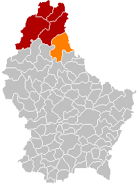
English: Parc Hosingen municipality location
Français : Situation de la commune luxembourgeoise du Parc Hosingen
Lëtzebuergesch: Localisatioun vun der Gemeng Parc Housen |
| Date | 26 October 2011 (original upload date) |
| Source | Transferred from lb.wikipedia to Commons. |
| Author | Les Meloures at Luxembourgish Wikipedia |
Licensing
| |
This work has been released into the public domain by its author, Les Meloures, at the English Wikipedia project. This applies worldwide. In case this is not legally possible: |
Original upload log
The original description page was here. All following user names refer to lb.wikipedia.
- 2011-10-27 19:01 Les Meloures 203×270× (3374 bytes) Verbessert Kaart
- 2011-10-26 23:32 Les Meloures 203×270× (3260 bytes) Localisatioun vun der Gemeng Parc Housen
File history
Click on a date/time to view the file as it appeared at that time.
| Date/Time | Thumbnail | Dimensions | User | Comment | |
|---|---|---|---|---|---|
| current | 17:52, 8 January 2018 | | 203 × 270 (7 KB) | NordNordWest | upd |
| 21:15, 10 November 2015 |  | 203 × 270 (5 KB) | NordNordWest | no more districts in Luxembourg | |
| 19:38, 28 October 2011 |  | 203 × 270 (3 KB) | MGA73bot2 | {{BotMoveToCommons|lb.wikipedia|year={{subst:CURRENTYEAR}}|month={{subst:CURRENTMONTHNAME}}|day={{subst:CURRENTDAY}}}} {{Information |Description={{lb|Localisatioun vun der Gemeng Parc Housen}} |Source=Transferred from [http://lb.wikipedia.org lb.wikipe |
File usage
The following page uses this file:
Global file usage
The following other wikis use this file:
- Usage on als.wikipedia.org
- Usage on ca.wikipedia.org
- Usage on de.wikipedia.org
- Usage on fa.wikipedia.org
- Usage on frr.wikipedia.org
- Usage on fr.wikipedia.org
- Usage on it.wikipedia.org
- Usage on lb.wikipedia.org
- Usage on li.wikipedia.org
- Usage on nds.wikipedia.org
- Usage on nl.wikipedia.org
- Usage on no.wikipedia.org
- Usage on pl.wikipedia.org
- Usage on sk.wikipedia.org
- Usage on sv.wikipedia.org
- Usage on www.wikidata.org
- Usage on zh-min-nan.wikipedia.org
- Usage on zh.wikipedia.org