File:Map of Barak Valley.jpg

Size of this preview: 600 × 600 pixels. Other resolutions: 240 × 240 pixels | 609 × 609 pixels.
Original file (609 × 609 pixels, file size: 94 KB, MIME type: image/jpeg)
| This is a file from the Wikimedia Commons. Information from its description page there is shown below. Commons is a freely licensed media file repository. You can help. |
| Description |
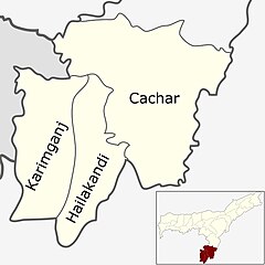
English: This is the map of Barak Valley |
| Source | http://www.mapsofindia.com/maps/assam/ |
| Author | mapsofindia.com |
| Permission (Reusing this file) |
http://www.mapsofindia.com/copyright/ |
| This work has been released into the public domain by its author, mapsofindia.com. This applies worldwide. In some countries this may not be legally possible; if so: mapsofindia.com grants anyone the right to use this work for any purpose, without any conditions, unless such conditions are required by law.
|
File history
Click on a date/time to view the file as it appeared at that time.
| Date/Time | Thumbnail | Dimensions | User | Comment | |
|---|---|---|---|---|---|
| current | 12:57, 19 June 2018 | | 609 × 609 (94 KB) | SlowPhoton | Clear version of the map |
| 23:28, 28 June 2012 |  | 538 × 401 (48 KB) | Tkdebnath | {{subst:Upload marker added by en.wp UW}} {{Information |Description = {{en|This is the map of Barak Valley}} |Source = http://www.mapsofindia.com/maps/assam/ |Author = mapsofindia.com |Permission = http://www.mapsofindia.com/copyright/ }} {{PD-autho... |
File usage
The following page uses this file:
Global file usage
The following other wikis use this file:
- Usage on as.wikipedia.org
- Usage on bn.wikipedia.org
- Usage on en.wikipedia.org
- Usage on es.wikipedia.org
- Usage on hi.wikipedia.org
- Usage on incubator.wikimedia.org
- Usage on ml.wikipedia.org
- Usage on sat.wikipedia.org
- Usage on ta.wikipedia.org
- Usage on www.wikidata.org