File:Periplous of the Erythraean Sea.svg

Size of this PNG preview of this SVG file: 800 × 564 pixels. Other resolutions: 320 × 226 pixels | 640 × 452 pixels | 1,024 × 722 pixels | 1,280 × 903 pixels | 2,560 × 1,806 pixels.
Original file (SVG file, nominally 1,280 × 903 pixels, file size: 1.39 MB)
| This is a file from the Wikimedia Commons. Information from its description page there is shown below. Commons is a freely licensed media file repository. You can help. |
Summary
| Description |
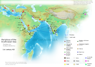
English: Periplous of the Erythreaen Sea map, according to the description from source text (https://el.wikisource.org/wiki/Περίπλους_τῆς_Ἐρυθράς_Θαλάσσης). Original names have been transcribed to Latin alphabet when possible. For the Greek names look at the respective Greek version of the map.
Ελληνικά: Χάρτης του περίπλου της Ερυθράς Θαλάσσης(Αγγλική έκδοση), σύμφωνα με την περιγραφή του κειμένου (https://el.wikisource.org/wiki/Περίπλους_τῆς_Ἐρυθράς_Θαλάσσης). हिन्दी: एरिथ्रेअन सागर के पेरिप्लस के नाम, मार्ग और स्थान
Català: Mapa del Periple de la Mar Eritrea, segons la descripció de la font (https://el.wikisource.org/wiki/Περίπλους_τῆς_Ἐρυθράς_Θαλάσσης). Els noms originals s'han transcrit a l'alfabet llatí quan ha estat possible. Per als noms grecs mireu la versió grega del mapa. |
| Date | |
| Source | Own work |
| Author | George Tsiagalakis |
| Permission (Reusing this file) |
Mention author and licence when using this work, e.g. "George Tsiagalakis / CC-BY-SA-4 licence" |
| Other versions |
|


This W3C-unspecified vector image was created with Inkscape .

|
This SVG file contains embedded text that can be translated into your language, using any capable SVG editor, text editor or the SVG Translate tool. For more information see: About translating SVG files. |
Licensing
I, the copyright holder of this work, hereby publish it under the following license:
| Multi-licensed with all versions of the Creative Commons Attribution Share-Alike License | ||
| I agree to multi-license my contributions, unless otherwise stated, under the GFDL and the Creative Commons Attribution Share-Alike license version 1.0, version 2.0, version 2.5, version 3.0, and all future versions of the Creative Commons Attribution Share-Alike license. Please be aware that other contributors might not do the same, so if you want to use my contributions under the Creative Commons terms, please check the CC dual-license and Multi-licensing guides. | ||

|
Permission is granted to copy, distribute and/or modify this document under the terms of the GNU Free Documentation License, Version 1.2 or any later version published by the Free Software Foundation; with no Invariant Sections, no Front-Cover Texts, and no Back-Cover Texts. A copy of the license is included in the section entitled GNU Free Documentation License. |
This file is licensed under the Creative Commons Attribution-Share Alike 4.0 International, 3.0 Unported, 2.5 Generic, 2.0 Generic and 1.0 Generic license.
- You are free:
- to share – to copy, distribute and transmit the work
- to remix – to adapt the work
- Under the following conditions:
- attribution – You must give appropriate credit, provide a link to the license, and indicate if changes were made. You may do so in any reasonable manner, but not in any way that suggests the licensor endorses you or your use.
- share alike – If you remix, transform, or build upon the material, you must distribute your contributions under the same or compatible license as the original.
File history
Click on a date/time to view the file as it appeared at that time.
| Date/Time | Thumbnail | Dimensions | User | Comment | |
|---|---|---|---|---|---|
| current | 17:48, 29 September 2023 | | 1,280 × 903 (1.39 MB) | Joutbis | File uploaded using svgtranslate tool (https://svgtranslate.toolforge.org/). Added translation for ca. |
| 17:33, 29 September 2023 |  | 1,280 × 903 (1.38 MB) | Joutbis | File uploaded using svgtranslate tool (https://svgtranslate.toolforge.org/). Added translation for ca. | |
| 21:13, 1 February 2023 |  | 1,280 × 903 (1.32 MB) | Theklan | File uploaded using svgtranslate tool (https://svgtranslate.toolforge.org/). Added translation for eu. | |
| 19:12, 9 January 2022 |  | 1,280 × 903 (1.28 MB) | Mr. Ibrahem | Reverted to version as of 11:44, 6 May 2021 (UTC) | |
| 13:29, 9 January 2022 |  | 1,280 × 903 (1.28 MB) | Mr. Ibrahem | File uploaded using svgtranslate tool (https://svgtranslate.toolforge.org/). Added translation for ar. | |
| 11:44, 6 May 2021 |  | 1,280 × 903 (1.28 MB) | Andrei Stroe | File uploaded using svgtranslate tool (https://svgtranslate.toolforge.org/). Added translation for ro. | |
| 16:10, 31 January 2015 |  | 1,280 × 903 (1.28 MB) | Gts-tg | Small updates in spelling of city names | |
| 15:39, 31 January 2015 |  | 1,280 × 903 (1.28 MB) | Gts-tg | More accurate positioning for Nikon(os) and Sarapion(os), corresponding to modern Barawe and Mogadishu respectively. Improved legibility of place names | |
| 03:15, 29 January 2015 |  | 1,280 × 903 (1.28 MB) | Gts-tg | Updates as [https://en.wikipedia.org/wiki/User_talk:Gts-tg#Periplus_svg indicated by Wikipedia editors] | |
| 17:31, 26 December 2014 |  | 1,280 × 903 (1.28 MB) | Gts-tg | User created page with UploadWizard |
File usage
The following 2 pages use this file:
Global file usage
The following other wikis use this file:
- Usage on af.wikipedia.org
- Usage on ar.wikipedia.org
- Usage on arz.wikipedia.org
- Usage on az.wikipedia.org
- Usage on bg.wikipedia.org
- Usage on bn.wikipedia.org
- Usage on ca.wikipedia.org
- Usage on ceb.wikipedia.org
- Usage on cs.wikipedia.org
- Usage on da.wikipedia.org
- Usage on de.wikipedia.org
- Usage on el.wikipedia.org
- Usage on en.wikipedia.org
- Arabian Sea
- History of Cambodia
- Foreign relations of Ethiopia
- Red Sea
- Kozhikode
- Kochi
- Malappuram district
- Tamils
- Roman Egypt
- Spice trade
- Trade route
- Bharuch
- History of South India
- Kollam
- Barbarikon
- Hippalus
- Islam in India
- Opone
- Mappila Muslims
- Sino-Roman relations
- Christianity in India
- Timeline of international trade
View more global usage of this file.