File:Positions of ancient continents, 550 million years ago.jpg
Size of this preview: 600 × 600 pixels. Other resolutions: 240 × 240 pixels | 480 × 480 pixels | 820 × 820 pixels.
Original file (820 × 820 pixels, file size: 426 KB, MIME type: image/jpeg)
| This is a file from the Wikimedia Commons. Information from its description page there is shown below. Commons is a freely licensed media file repository. You can help. |

|
This geology image could be re-created using vector graphics as an SVG file. This has several advantages; see Commons:Media for cleanup for more information. If an SVG form of this image is available, please upload it and afterwards replace this template with
{{vector version available|new image name}}.
It is recommended to name the SVG file “Positions of ancient continents, 550 million years ago.svg”—then the template Vector version available (or Vva) does not need the new image name parameter. |


|
This map has been uploaded by Electionworld from en.wikipedia.org to enable the |
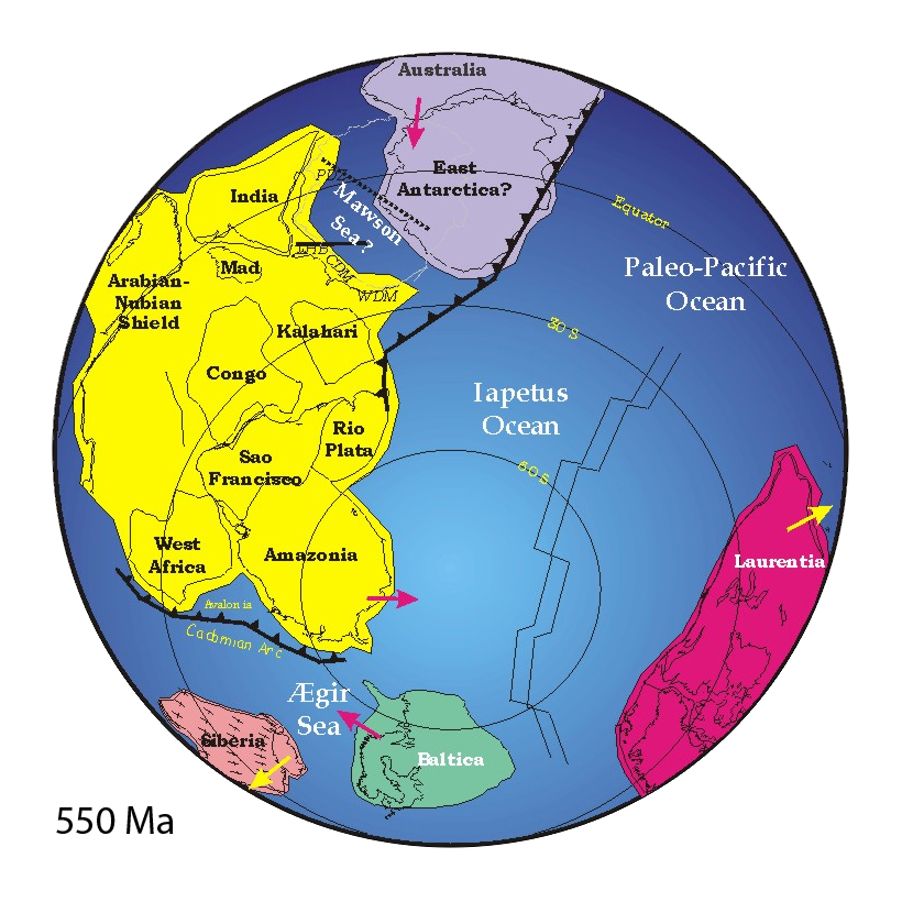
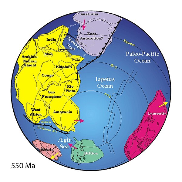
("Mad" = "Madagascar")
Summary
http://www.clas.ufl.edu/users/jmeert/550.jpg
Licensing
| I, the copyright holder of this work, release this work into the public domain. This applies worldwide. In some countries this may not be legally possible; if so: I grant anyone the right to use this work for any purpose, without any conditions, unless such conditions are required by law. |
File history
Click on a date/time to view the file as it appeared at that time.
| Date/Time | Thumbnail | Dimensions | User | Comment | |
|---|---|---|---|---|---|
| current | 15:44, 25 May 2007 | | 820 × 820 (426 KB) | Wiggum | |
| 19:27, 3 December 2006 |  | 800 × 889 (160 KB) | Electionworld | {{ew|en|Jmeert}} == Summary == http://www.clas.ufl.edu/users/jmeert/550.jpg == Licensing == {{PD-self}} |
File usage
The following 2 pages use this file:
Global file usage
The following other wikis use this file:
- Usage on af.wikipedia.org
- Usage on ar.wikipedia.org
- Usage on bat-smg.wikipedia.org
- Usage on bg.wikipedia.org
- Usage on bs.wikipedia.org
- Usage on ca.wikipedia.org
- Usage on cs.wikipedia.org
- Usage on cv.wikipedia.org
- Usage on cy.wikipedia.org
- Usage on da.wikipedia.org
- Usage on de.wikipedia.org
- Superkontinent
- Uluru
- Iapetus (Ozean)
- Ediacarium
- Rodinia
- Pannotia
- Proto-Tethys
- Comley Series
- Ostgondwana
- Yamato-Belgica-Komplex
- Geologie Ostantarktikas
- Westgondwana
- Geologie Spitzbergens
- Geologie der Ostghats
- Shillong-Plateau
- Tektonische Entwicklung des indischen Subkontinents
- Geologie des Niedrigen Himalayas
- Zerfall Gondwanas
- Usage on en.wikipedia.org
View more global usage of this file.