File:Prefecture Tours.jpg

Size of this preview: 800 × 595 pixels. Other resolutions: 320 × 238 pixels | 640 × 476 pixels | 1,024 × 761 pixels | 1,280 × 952 pixels | 2,560 × 1,903 pixels | 3,012 × 2,239 pixels.
Original file (3,012 × 2,239 pixels, file size: 1.73 MB, MIME type: image/jpeg)
| This is a file from the Wikimedia Commons. Information from its description page there is shown below. Commons is a freely licensed media file repository. You can help. |
|
This building is indexed in the base Mérimée, a database of architectural heritage maintained by the French Ministry of Culture, under the reference PA00098264
|
Summary
| Description |
Brezhoneg: Prefeti departamant an Indre-et-Loire e Teurgn
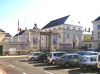
Français : Préfecture d'Indre et Loire à Tours |
| Source | Own work |
| Author | Guill37 |
| Object location | | View this and other nearby images on: OpenStreetMap |
|---|
Licensing
I, the copyright holder of this work, hereby publish it under the following licenses:

|
Permission is granted to copy, distribute and/or modify this document under the terms of the GNU Free Documentation License, Version 1.2 or any later version published by the Free Software Foundation; with no Invariant Sections, no Front-Cover Texts, and no Back-Cover Texts. A copy of the license is included in the section entitled GNU Free Documentation License. |
This file is licensed under the Creative Commons Attribution-Share Alike 4.0 International, 3.0 Unported, 2.5 Generic, 2.0 Generic and 1.0 Generic license.
- You are free:
- to share – to copy, distribute and transmit the work
- to remix – to adapt the work
- Under the following conditions:
- attribution – You must give appropriate credit, provide a link to the license, and indicate if changes were made. You may do so in any reasonable manner, but not in any way that suggests the licensor endorses you or your use.
- share alike – If you remix, transform, or build upon the material, you must distribute your contributions under the same or compatible license as the original.
You may select the license of your choice.
File history
Click on a date/time to view the file as it appeared at that time.
| Date/Time | Thumbnail | Dimensions | User | Comment | |
|---|---|---|---|---|---|
| current | 02:21, 21 July 2018 | | 3,012 × 2,239 (1.73 MB) | Tu me connais pas | |
| 17:38, 18 October 2008 |  | 2,531 × 1,251 (856 KB) | Guill37~commonswiki | {{Information |Description= |Source= |Date= |Author= |Permission= |other_versions= }} | |
| 17:34, 18 October 2008 |  | 3,012 × 1,263 (1,019 KB) | Guill37~commonswiki | {{Information |Description= |Source= |Date= |Author= |Permission= |other_versions= }} | |
| 17:08, 18 October 2008 |  | 3,072 × 2,304 (1.74 MB) | Guill37~commonswiki | {{Information |Description= |Source= |Date= |Author= |Permission= |other_versions= }} | |
| 17:01, 18 October 2008 |  | 3,012 × 1,504 (1.22 MB) | Guill37~commonswiki | {{Information |Description= |Source= |Date= |Author= |Permission= |other_versions= }} | |
| 14:10, 18 October 2008 |  | 3,012 × 2,239 (1.73 MB) | Guill37~commonswiki | {{Information |Description={{fr|1=Préfecture d'Indre et Loire à Tours. }} |Source=travail personnel (own work) |Author=Guill37 |Date= |Permission= |other_versions= }} <!--{{ImageUpload|full}}--> <!--{{ImageUpload|basic}}--> |
File usage
The following page uses this file:
Global file usage
The following other wikis use this file:
- Usage on ar.wikipedia.org
- Usage on az.wikipedia.org
- Usage on ca.wikipedia.org
- Usage on ceb.wikipedia.org
- Usage on ce.wikipedia.org
- Usage on cs.wikipedia.org
- Usage on cy.wikipedia.org
- Usage on de.wikivoyage.org
- Usage on el.wikipedia.org
- Usage on en.wikipedia.org
- Usage on fr.wikipedia.org
- Indre-et-Loire
- Tours
- Utilisateur:Guill37
- Discussion utilisateur:Mikeo1938
- Conférence de Briare
- Réunion du Conseil suprême interallié de Tours
- Hôtel de préfecture d'Indre-et-Loire
- Liste des hôtels de préfecture de France
- Liste des monuments historiques de Tours
- Histoire de Tours
- Liste des monuments historiques protégés en 1917
- Usage on fr.wikinews.org
- Usage on fr.wikivoyage.org
- Usage on fr.wiktionary.org
- Usage on gl.wikipedia.org
- Usage on hak.wikipedia.org
- Usage on he.wikipedia.org
- Usage on hy.wikipedia.org
- Usage on ia.wikipedia.org
- Usage on it.wikivoyage.org
- Usage on lld.wikipedia.org
- Usage on oc.wikipedia.org
- Usage on pl.wikipedia.org
- Usage on ro.wikipedia.org
- Usage on ru.wikipedia.org
- Usage on sco.wikipedia.org
- Usage on sq.wikipedia.org
- Usage on sr.wikipedia.org
- Usage on th.wikipedia.org
- Usage on tr.wikipedia.org
- Usage on ur.wikipedia.org
- Usage on uz.wikipedia.org
- Usage on www.wikidata.org
- Usage on zh-min-nan.wikipedia.org