File:Sassanid Empire 620.png
No higher resolution available.
Sassanid_Empire_620.png (250 × 165 pixels, file size: 3 KB, MIME type: image/png)
| This is a file from the Wikimedia Commons. Information from its description page there is shown below. Commons is a freely licensed media file repository. You can help. |
Summary
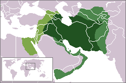
| Description | Sassanid Empire at its greatest extent. ca. 620 CE: lighter: vassal territories; more yellow: 620 conquest against Byz. Empire |
| Date | |
| Source | own work - based on WP locator maps Category:Locator_maps; boundaries as per en:Image:Sassanid Empire.jpg |
| Author | self, based on WP locator maps Category:Locator_maps |
| Permission (Reusing this file) |
GFDL (derived from PD work) |

|
File:Sassanid Empire 620-627.svg is a vector version of this file. It should be used in place of this PNG file when not inferior.
File:Sassanid Empire 620.png → File:Sassanid Empire 620-627.svg
For more information, see Help:SVG. |
 |
Licensing
I, the copyright holder of this work, hereby publish it under the following licenses:

|
Permission is granted to copy, distribute and/or modify this document under the terms of the GNU Free Documentation License, Version 1.2 or any later version published by the Free Software Foundation; with no Invariant Sections, no Front-Cover Texts, and no Back-Cover Texts. A copy of the license is included in the section entitled GNU Free Documentation License. |
| This file is licensed under the Creative Commons Attribution-Share Alike 3.0 Unported license. | ||
| ||
| This licensing tag was added to this file as part of the GFDL licensing update. |
This file is licensed under the Creative Commons Attribution-Share Alike 2.5 Generic, 2.0 Generic and 1.0 Generic license.
- You are free:
- to share – to copy, distribute and transmit the work
- to remix – to adapt the work
- Under the following conditions:
- attribution – You must give appropriate credit, provide a link to the license, and indicate if changes were made. You may do so in any reasonable manner, but not in any way that suggests the licensor endorses you or your use.
- share alike – If you remix, transform, or build upon the material, you must distribute your contributions under the same or compatible license as the original.
You may select the license of your choice.
File history
Click on a date/time to view the file as it appeared at that time.
| Date/Time | Thumbnail | Dimensions | User | Comment | |
|---|---|---|---|---|---|
| current | 13:25, 27 November 2022 | | 250 × 165 (3 KB) | Gyalu22 | removed date |
| 16:40, 8 May 2018 |  | 250 × 165 (8 KB) | Trecătorul răcit | Empire itself, vassal territories and conquests of 620 distinguished | |
| 11:53, 14 January 2011 |  | 250 × 165 (6 KB) | Cplakidas | more realistic borders & corrections, per http://ecai.org/sasanianweb/sasanianmapmenu.html | |
| 14:59, 15 February 2007 |  | 250 × 165 (5 KB) | Aivazovsky~commonswiki | ||
| 14:52, 15 February 2007 |  | 250 × 165 (5 KB) | Aivazovsky~commonswiki | Fixing Caucasus borders | |
| 14:27, 9 August 2006 |  | 250 × 165 (6 KB) | Cp | {{Information |Description=Sassanid Empire at its greatest extent. ca. 610 CE. |Source=own work - based on WP locator maps Category:Locator_maps; boundaries as per en:Image:Sassanid Empire.jpg |Author=self, based on WP locator maps [[:Category:Lo |
File usage
The following page uses this file:
Global file usage
The following other wikis use this file:
- Usage on ar.wikipedia.org
- Usage on az.wikipedia.org
- Usage on ba.wikipedia.org
- Usage on be-tarask.wikipedia.org
- Usage on be.wikipedia.org
- Usage on ca.wikipedia.org
- Usage on cs.wikipedia.org
- Usage on de.wikipedia.org
- Usage on en.wikipedia.org
- Usage on es.wikipedia.org
- Usage on fa.wikipedia.org
- Usage on fi.wikibooks.org
- Usage on fr.wikipedia.org
- Usage on hi.wikipedia.org
- Usage on hu.wikipedia.org
- Usage on hy.wikipedia.org
- Usage on id.wikipedia.org
- Usage on it.wikipedia.org
View more global usage of this file.