File:SeamontDavidson expedition bathymetric-2002.jpg
No higher resolution available.
SeamontDavidson_expedition_bathymetric-2002.jpg (600 × 478 pixels, file size: 59 KB, MIME type: image/jpeg)
| This is a file from the Wikimedia Commons. Information from its description page there is shown below. Commons is a freely licensed media file repository. You can help. |
Summary
| Description |
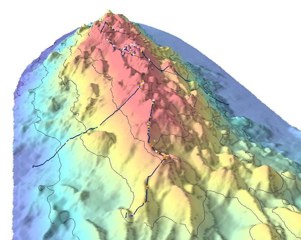
English: Bathymetric showing details of part of Davidson Seamount. The lines indicate the path of the 2002 expedition, and the dots signifigant coral nurseries
Français : Relevé bathymétrique montrant les détails du relief sous-marin du Mont Davidson. les lignes indiquent les lieux étudiés par l'expédition de 2002, et les points désignent les surseries coralliennes |
| Date | import on Commons : 2010/10/30 |
| Source | Direct link File page |
| Author | C. King/[1]/[2] |
| Permission (Reusing this file) |
The above two organizations are a part of NOAA; thus it is public domain (see below) |
Licensing
This image is in the public domain because it contains materials that originally came from the U.S. National Oceanic and Atmospheric Administration, taken or made as part of an employee's official duties.
|
File history
Click on a date/time to view the file as it appeared at that time.
| Date/Time | Thumbnail | Dimensions | User | Comment | |
|---|---|---|---|---|---|
| current | 08:21, 30 October 2010 | | 600 × 478 (59 KB) | Lamiot | {{Information |Description= {{en|Bathymetric showing details of part of Davidson Seamount. The lines indicate the path of the 2002 expedition, and the dots signifigant coral nurseries}} {{fr|Relevé bathymétrique montrant les détails du relief sous-mari |
File usage
The following page uses this file:
Global file usage
The following other wikis use this file:
- Usage on bs.wikipedia.org
- Usage on en.wikipedia.org
- Usage on fa.wikipedia.org
- Usage on fr.wikipedia.org
- Usage on gl.wikipedia.org
- Usage on he.wikipedia.org
- Usage on mk.wikipedia.org
- Usage on nl.wikipedia.org
- Usage on sr.wikipedia.org
- Usage on th.wikipedia.org
- Usage on tr.wikipedia.org
- Usage on tt.wikipedia.org
- Usage on www.wikidata.org