File:Spain Castile-La Mancha location map.svg

Size of this PNG preview of this SVG file: 512 × 517 pixels. Other resolutions: 238 × 240 pixels | 475 × 480 pixels | 761 × 768 pixels | 1,014 × 1,024 pixels | 2,028 × 2,048 pixels.
Original file (SVG file, nominally 512 × 517 pixels, file size: 825 KB)
| This is a file from the Wikimedia Commons. Information from its description page there is shown below. Commons is a freely licensed media file repository. You can help. |
Summary
| Description |
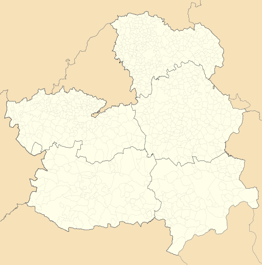
English: Location map of Castile-La Mancha
Equirectangular projection, N/S stretching 130 %. Geographic limits of the map:
Español: Mapa de localización de Castilla-La Mancha
Proyección equirrectangular, N/S estirada 130 %. Límites geográficos del mapa:
|
|
| Date | ||
| Source | Own work based on: EspañaLoc.svg by HansenBCN and Spain location map.svg by NordNordWest | |
| Author | Miguillen | |
| SVG development | This locator map was created with Inkscape.
|
Licensing
Miguillen, the copyright holder of this work, hereby publishes it under the following license:
This file is licensed under the Creative Commons Attribution-Share Alike 3.0 Unported license.
Attribution: Miguillen
- You are free:
- to share – to copy, distribute and transmit the work
- to remix – to adapt the work
- Under the following conditions:
- attribution – You must give appropriate credit, provide a link to the license, and indicate if changes were made. You may do so in any reasonable manner, but not in any way that suggests the licensor endorses you or your use.
- share alike – If you remix, transform, or build upon the material, you must distribute your contributions under the same or compatible license as the original.
File history
Click on a date/time to view the file as it appeared at that time.
| Date/Time | Thumbnail | Dimensions | User | Comment | |
|---|---|---|---|---|---|
| current | 10:29, 20 May 2010 | | 512 × 517 (825 KB) | Miguillen | elimino marco |
| 10:21, 20 May 2010 |  | 512 × 517 (824 KB) | Miguillen | == {{int:filedesc}} == {{Information |Description= {{en|Location map of Castilla-La Mancha}} Equirectangular projection, N/S stretching 130 %. Geographic limits of the map: * N: 41.477948° N * S: 37.892254° N * W: 5.485552 |
File usage
The following 4 pages use this file:
Global file usage
The following other wikis use this file:
- Usage on ar.wikipedia.org
- Usage on ast.wikipedia.org
- Usage on azb.wikipedia.org
- Usage on ba.wikipedia.org
- Usage on bg.wikipedia.org
- Usage on bn.wikipedia.org
- Usage on ceb.wikipedia.org
- Usage on cs.wikipedia.org
- Usage on cv.wikipedia.org
- Usage on de.wikipedia.org
- Kernkraftwerk José Cabrera
- Kernkraftwerk Trillo
- Wikipedia:Kartenwerkstatt/Positionskarten/Europa
- Estadio Carlos Belmonte
- Campo Municipal de Deportes Nuestra Señora de la Caridad
- Vorlage:Positionskarte Spanien Kastilien-La Mancha
- Estadio Pedro Escartín
- Base Aérea de Las Minas
- Aeródromo de Robledillo de Mohernando
- Aeródromo de Almansa
- Aeródromo de Ontur
- Base Aérea de Cañadillas
- Puente de Alcántara (Toledo)
- Usage on en.wikipedia.org
View more global usage of this file.