File:TS Bill 2003.jpg

Size of this preview: 463 × 599 pixels. Other resolutions: 185 × 240 pixels | 371 × 480 pixels | 593 × 768 pixels | 791 × 1,024 pixels | 1,582 × 2,048 pixels | 6,801 × 8,801 pixels.
Original file (6,801 × 8,801 pixels, file size: 10.07 MB, MIME type: image/jpeg)
| This is a file from the Wikimedia Commons. Information from its description page there is shown below. Commons is a freely licensed media file repository. You can help. |
Summary
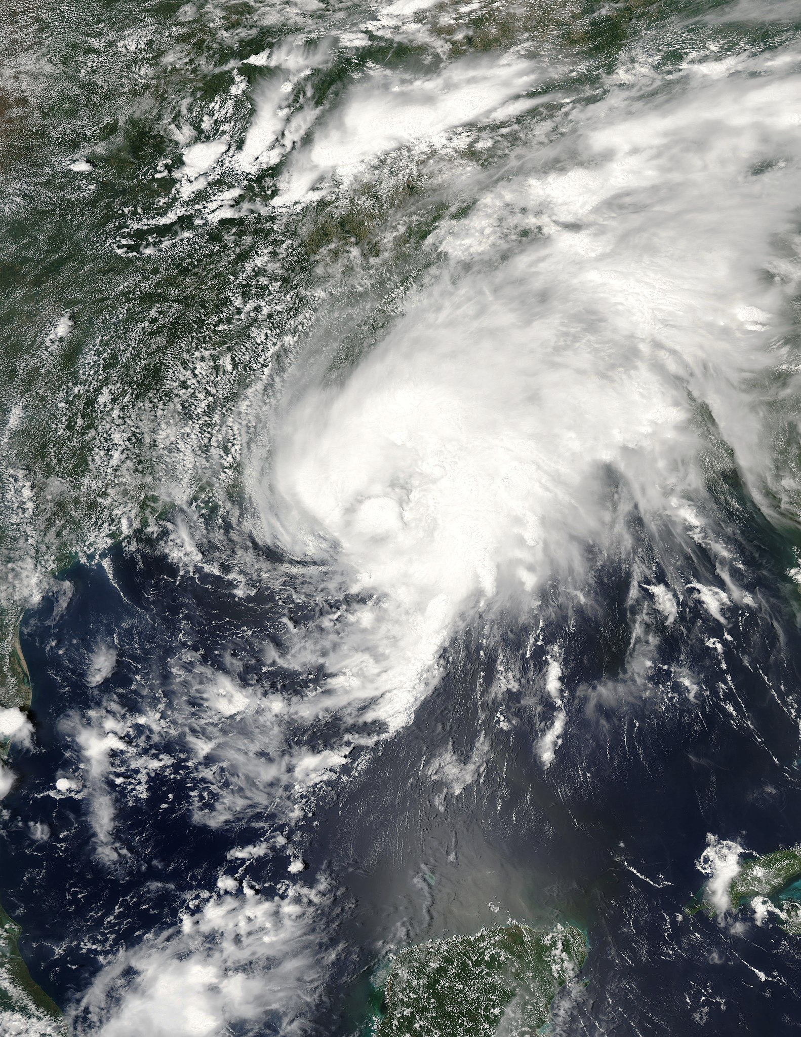
| Description | This Moderate Resolution Imaging Spectroradiometer (MODIS) image from the Aqua satellite shows Tropical Storm Bill making landfall over the Gulf Coast of the United States. The storm may look a bit disorganized, but the threat of heavy rains, tornados, and flooding persisted for parts of the South, East and Mid-Atlantic regions of the U.S. on July 1, 2003. | |||||
| Date | ||||||
| Source | http://earthobservatory.nasa.gov/NaturalHazards/natural_hazards_v2.php3?img_id=10755 | |||||
| Author | Image courtesy Jesse Allen, based on data from the MODIS Rapid Response Team at NASA GSFC | |||||
| Permission (Reusing this file) |
|

File history
Click on a date/time to view the file as it appeared at that time.
| Date/Time | Thumbnail | Dimensions | User | Comment | |
|---|---|---|---|---|---|
| current | 17:55, 23 November 2018 | | 6,801 × 8,801 (10.07 MB) | FleurDeOdile | better |
| 19:59, 1 May 2018 |  | 1,660 × 2,080 (740 KB) | CooperScience | Centering | |
| 22:12, 18 August 2006 |  | 5,892 × 6,157 (4 MB) | Good kitty | == Summary == {{Information |Description=This Moderate Resolution Imaging Spectroradiometer (MODIS) image from the Aqua satellite shows Tropical Storm Bill making landfall over the Gulf Coast of the United States. The storm may look a bit disorganized, bu |
File usage
The following page uses this file:
Global file usage
The following other wikis use this file:
- Usage on ar.wikipedia.org
- Usage on de.wikipedia.org
- Usage on en.wikipedia.org
- 2003 Atlantic hurricane season
- Tropical Storm Bill (2003)
- Portal:Tropical cyclones/Featured article/Tropical Storm Bill (2003)
- Timeline of the 2003 Atlantic hurricane season
- Wikipedia:Today's featured article/June 2017
- Wikipedia:Today's featured article/requests/Tropical Storm Bill (2003)
- Wikipedia:Today's featured article/June 29, 2017
- Wikipedia:Main Page history/2017 June 29
- Usage on es.wikipedia.org
- Usage on fr.wikipedia.org
- Usage on no.wikipedia.org
- Usage on pt.wikipedia.org
- Usage on www.wikidata.org
- Usage on zh.wikipedia.org
- Portal:美國/特色條目
- 2003年热带风暴比尔
- Talk:2003年热带风暴比尔
- Wikipedia:优良条目/2014年9月
- 2003年大西洋飓风季时间轴
- Wikipedia:优良条目/2014年9月4日
- Wikipedia:优良条目/2003年热带风暴比尔
- Wikipedia:典范条目/2014年7月
- Wikipedia:典范条目/2014年7月3日
- Wikipedia:典范条目/2003年热带风暴比尔
- Portal:美國/特色條目/152
- 2003年大西洋飓风季的风暴
- Wikipedia:典范条目/2016年6月
- Wikipedia:典范条目/2016年6月10日
- Wikipedia:典范条目/2018年9月
- Wikipedia:典范条目/2018年9月15日
- Wikipedia:典范条目/2022年5月
- Wikipedia:典范条目/2022年5月26日