File:TimezonesID.svg

Size of this PNG preview of this SVG file: 800 × 320 pixels. Other resolutions: 320 × 128 pixels | 640 × 256 pixels | 1,024 × 409 pixels | 1,280 × 511 pixels | 2,560 × 1,023 pixels | 1,875 × 749 pixels.
Original file (SVG file, nominally 1,875 × 749 pixels, file size: 355 KB)
| This is a file from the Wikimedia Commons. Information from its description page there is shown below. Commons is a freely licensed media file repository. You can help. |
Summary
| Description |
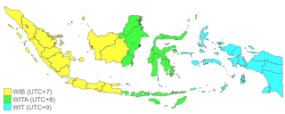
English: Timezones in Indonesia |
| Date | |
| Source | Own work based on File:Indonesia provinces outline map.svg |
| Author | Flix11 |
Licensing
I, the copyright holder of this work, hereby publish it under the following license:
This file is licensed under the Creative Commons Attribution-Share Alike 4.0 International license.
- You are free:
- to share – to copy, distribute and transmit the work
- to remix – to adapt the work
- Under the following conditions:
- attribution – You must give appropriate credit, provide a link to the license, and indicate if changes were made. You may do so in any reasonable manner, but not in any way that suggests the licensor endorses you or your use.
- share alike – If you remix, transform, or build upon the material, you must distribute your contributions under the same or compatible license as the original.
File history
Click on a date/time to view the file as it appeared at that time.
| Date/Time | Thumbnail | Dimensions | User | Comment | |
|---|---|---|---|---|---|
| current | 10:53, 24 July 2023 | 1,875 × 749 (355 KB) | SmallJarsWithGreenLabels | southwest papua | |
| 21:39, 12 December 2022 | 1,875 × 749 (349 KB) | Afrogindahood | Increase border thickness and color saturation | ||
| 21:12, 12 December 2022 | 1,875 × 749 (349 KB) | Afrogindahood | Addition of new provinces in Western New Guinea | ||
| 14:20, 12 December 2022 | 1,568 × 574 (218 KB) | Ibrahim Muizzuddin | Reverted to version as of 13:10, 24 August 2022 (UTC) Updating additional recent provinces in Papua | ||
| 13:14, 24 August 2022 | 1,875 × 750 (341 KB) | Afrogindahood | Changes on border thickness | ||
| 13:10, 24 August 2022 | 1,568 × 574 (218 KB) | Afrogindahood | Addition of new provinces in Western New Guinea | ||
| 13:52, 8 May 2021 | 512 × 196 (298 KB) | Flix11 | Reverted to version as of 04:16, 3 July 2020 (UTC) 1 island less but far tidier codes. Afrogindahood please make it editable. | ||
| 13:49, 8 May 2021 |  | 785 × 360 (232 KB) | Flix11 | Reverted to version as of 13:44, 8 May 2021 (UTC) | |
| 13:46, 8 May 2021 | 512 × 196 (298 KB) | Flix11 | Reverted to version as of 13:43, 8 May 2021 (UTC) | ||
| 13:44, 8 May 2021 |  | 785 × 360 (232 KB) | Flix11 | Reverted to version as of 21:02, 14 October 2020 (UTC) |
File usage
The following page uses this file:
Global file usage
The following other wikis use this file:
- Usage on ace.wikipedia.org
- Usage on ar.wikipedia.org
- Usage on ban.wikipedia.org
- Usage on bn.wikipedia.org
- Usage on ceb.wikipedia.org
- Usage on cs.wikipedia.org
- Usage on da.wikipedia.org
- Usage on de.wikivoyage.org
- Usage on el.wikipedia.org
- Usage on en.wikipedia.org
- Usage on en.wikivoyage.org
- Usage on et.wikipedia.org
- Usage on fa.wikipedia.org
- Usage on fr.wikivoyage.org
- Usage on ga.wikipedia.org
- Usage on hi.wikipedia.org
- Usage on hr.wikipedia.org
- Usage on id.wikipedia.org
View more global usage of this file.