File:Topographic map of Buru-en.svg

Size of this PNG preview of this SVG file: 800 × 598 pixels. Other resolutions: 320 × 239 pixels | 640 × 479 pixels | 1,024 × 766 pixels | 1,280 × 957 pixels | 2,560 × 1,915 pixels | 1,972 × 1,475 pixels.
Original file (SVG file, nominally 1,972 × 1,475 pixels, file size: 1.14 MB)
| This is a file from the Wikimedia Commons. Information from its description page there is shown below. Commons is a freely licensed media file repository. You can help. |
Summary
| Description |
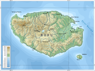
English: Topographic map of Buru.
Bahasa Indonesia: Peta topografi Pulau Buru. |
| Date | |
| Source |
Own work. Self-made in Inkscape and GIMP.
|
| Author | Oona Räisänen |
| Other versions |
Derivative works of this file: |
| SVG development |
Licensing
I, the copyright holder of this work, hereby publish it under the following licenses:
This file is licensed under the Creative Commons Attribution-Share Alike 3.0 Unported license.
- You are free:
- to share – to copy, distribute and transmit the work
- to remix – to adapt the work
- Under the following conditions:
- attribution – You must give appropriate credit, provide a link to the license, and indicate if changes were made. You may do so in any reasonable manner, but not in any way that suggests the licensor endorses you or your use.
- share alike – If you remix, transform, or build upon the material, you must distribute your contributions under the same or compatible license as the original.

|
Permission is granted to copy, distribute and/or modify this document under the terms of the GNU Free Documentation License, Version 1.2 or any later version published by the Free Software Foundation; with no Invariant Sections, no Front-Cover Texts, and no Back-Cover Texts. A copy of the license is included in the section entitled GNU Free Documentation License. |
You may select the license of your choice.
File history
Click on a date/time to view the file as it appeared at that time.
| Date/Time | Thumbnail | Dimensions | User | Comment | |
|---|---|---|---|---|---|
| current | 08:51, 16 April 2011 | | 1,972 × 1,475 (1.14 MB) | Mysid | remove unnamed town dots |
| 14:34, 12 April 2011 |  | 1,972 × 1,475 (1.14 MB) | Mysid | bugfix #2 | |
| 14:33, 12 April 2011 |  | 1,972 × 1,475 (1.14 MB) | Mysid | bugfix #1 | |
| 14:31, 12 April 2011 |  | 1,972 × 1,475 (1.14 MB) | Mysid | {{Information |Description ={{en|1=Topographic map of Buru.}} |Source ={{own}}. Self-made in Inkscape and GIMP. |Author =Mysid |Date =2010-04-12 |Permission = |other_versions = }} [[Category |
File usage
The following page uses this file:
Global file usage
The following other wikis use this file:
- Usage on ar.wikipedia.org
- Usage on arz.wikipedia.org
- Usage on az.wikipedia.org
- İstifadəçi müzakirəsi:Cekli829
- İstifadəçi müzakirəsi:Namikilisu
- İstifadəçi müzakirəsi:Firuza
- İstifadəçi müzakirəsi:Qızılbaş
- İstifadəçi müzakirəsi:Rəşid Nurməmmədov
- İstifadəçi müzakirəsi:Vüsal
- İstifadəçi müzakirəsi:Anar kerimxanov
- İstifadəçi müzakirəsi:Natəvan.R.
- İstifadəçi müzakirəsi:CalalC99
- Vikipediya:Həftənin seçilmiş məqaləsi/mart 2019
- Vikipediya:Həftənin seçilmiş məqaləsi/13. Həftə 2019
- İstifadəçi müzakirəsi:Araz Yaquboglu/Arxiv 10
- İstifadəçi müzakirəsi:Turkmen/Arxiv 4
- İstifadəçi müzakirəsi:Masalli qasimli/Arxiv 5
- İstifadəçi müzakirəsi:White Demon/Arxiv 6
- Usage on be.wikipedia.org
- Usage on bg.wikipedia.org
- Usage on br.wikipedia.org
- Usage on ca.wikipedia.org
- Usage on ceb.wikipedia.org
- Usage on cy.wikipedia.org
- Usage on de.wikipedia.org
- Usage on el.wikipedia.org
- Usage on en.wikipedia.org
- Usage on en.wikivoyage.org
- Usage on eo.wikipedia.org
- Usage on es.wikipedia.org
- Usage on eu.wikipedia.org
- Usage on fa.wikipedia.org
- Usage on fi.wikipedia.org
- Usage on fr.wikipedia.org
- Usage on id.wikipedia.org
- Usage on incubator.wikimedia.org
- Usage on lv.wikipedia.org
- Usage on ms.wikipedia.org
- Usage on nl.wikipedia.org
- Usage on nn.wikipedia.org
View more global usage of this file.