File:Topographic map of Saint Helena-en.svg

Size of this PNG preview of this SVG file: 740 × 600 pixels. Other resolutions: 296 × 240 pixels | 592 × 480 pixels | 948 × 768 pixels | 1,264 × 1,024 pixels | 2,527 × 2,048 pixels | 802 × 650 pixels.
Original file (SVG file, nominally 802 × 650 pixels, file size: 583 KB)
| This is a file from the Wikimedia Commons. Information from its description page there is shown below. Commons is a freely licensed media file repository. You can help. |
Summary
| Description |
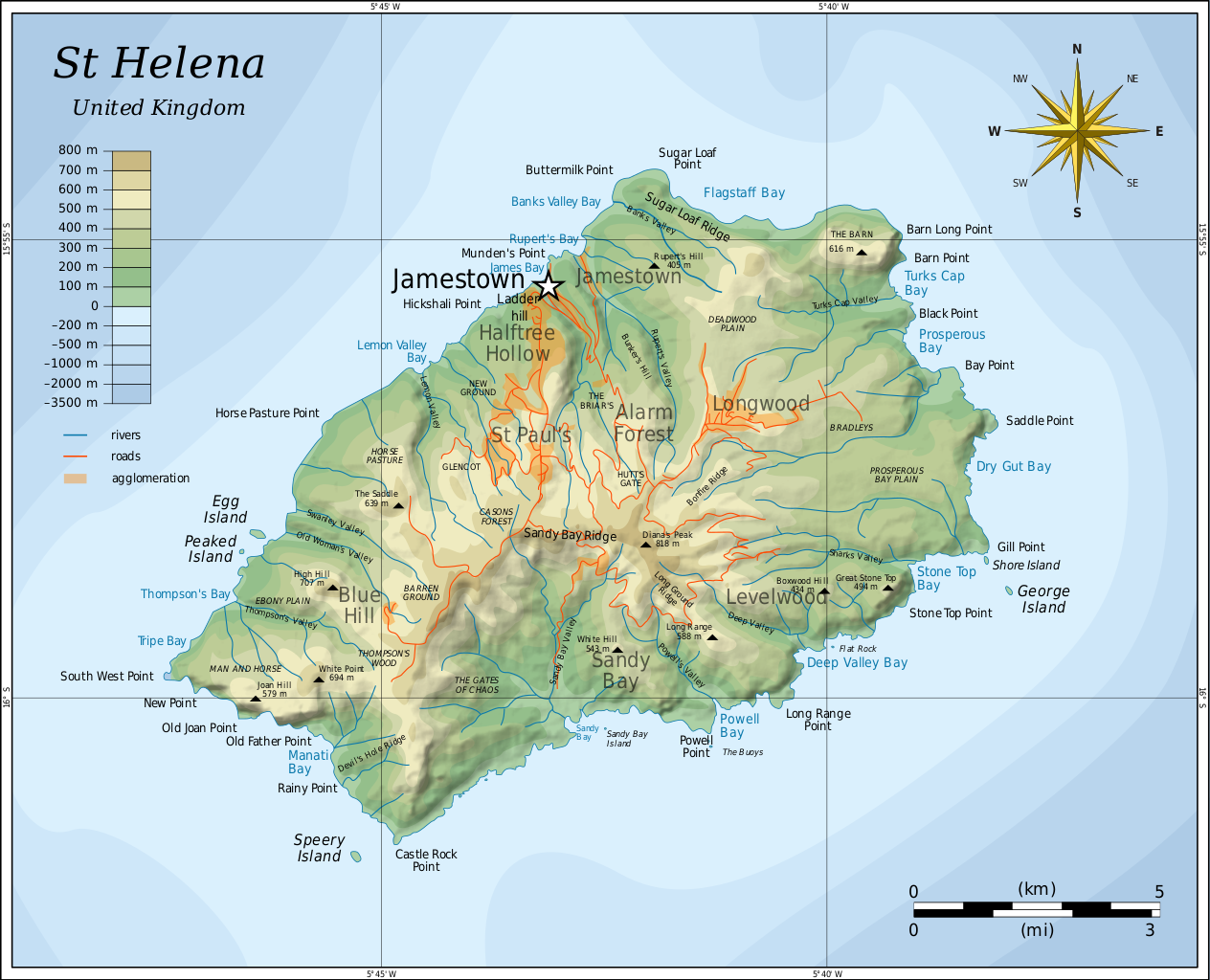
English: Topographic map of the British island of Saint Helena. |
| Date | |
| Source |
Self-made in Inkscape. Based on several sources:
|
| Author | Oona Räisänen (Mysid) |
| Other versions |
Derivative works of this file: |

|
This SVG file contains embedded text that can be translated into your language, using any capable SVG editor, text editor or the SVG Translate tool. For more information see: About translating SVG files. |
Licensing
I, the copyright holder of this work, hereby publish it under the following licenses:
This file is licensed under the Creative Commons Attribution-Share Alike 3.0 Unported license.
- You are free:
- to share – to copy, distribute and transmit the work
- to remix – to adapt the work
- Under the following conditions:
- attribution – You must give appropriate credit, provide a link to the license, and indicate if changes were made. You may do so in any reasonable manner, but not in any way that suggests the licensor endorses you or your use.
- share alike – If you remix, transform, or build upon the material, you must distribute your contributions under the same or compatible license as the original.

|
Permission is granted to copy, distribute and/or modify this document under the terms of the GNU Free Documentation License, Version 1.2 or any later version published by the Free Software Foundation; with no Invariant Sections, no Front-Cover Texts, and no Back-Cover Texts. A copy of the license is included in the section entitled GNU Free Documentation License. |
You may select the license of your choice.
File history
Click on a date/time to view the file as it appeared at that time.
| Date/Time | Thumbnail | Dimensions | User | Comment | |
|---|---|---|---|---|---|
| current | 05:54, 10 August 2010 | | 802 × 650 (583 KB) | Mysid | legend for roads, rivers, agglomeration |
| 21:42, 9 August 2010 |  | 802 × 650 (580 KB) | Mysid | bugfix #2 | |
| 21:40, 9 August 2010 |  | 802 × 650 (260 KB) | Mysid | bugfix | |
| 21:27, 9 August 2010 |  | 647 × 594 (579 KB) | Mysid | {{Information |Description={{en|1=Topographic map of the British island of w:Saint Helena.}} |Source=Self-made in Inkscape. Based on several sources. |Author=Mysid |Date=2010-08-10 |Permission= |other_versions= }} {{translation possi |
File usage
The following page uses this file:
Global file usage
The following other wikis use this file:
- Usage on af.wikipedia.org
- Usage on als.wikipedia.org
- Usage on ar.wikipedia.org
- Usage on arz.wikipedia.org
- Usage on ast.wikipedia.org
- Usage on bg.wikipedia.org
- Usage on bn.wikipedia.org
- Usage on bs.wikipedia.org
- Usage on ca.wikipedia.org
- Usage on ckb.wikipedia.org
- Usage on da.wikipedia.org
- Usage on el.wikipedia.org
- Usage on en.wikipedia.org
- Usage on eo.wikipedia.org
- Usage on es.wikipedia.org
- Usage on eu.wikipedia.org
- Usage on fa.wikipedia.org
- Usage on fi.wikipedia.org
- Usage on fy.wikipedia.org
- Usage on ga.wikipedia.org
- Usage on gl.wikipedia.org
- Usage on gv.wikipedia.org
- Usage on he.wikipedia.org
- Usage on hr.wikipedia.org
- Usage on hu.wikipedia.org
- Usage on hy.wikipedia.org
- Usage on ie.wikipedia.org
- Usage on io.wikipedia.org
- Usage on it.wikipedia.org
View more global usage of this file.