File:USA Territorial Growth 1840.jpg

Size of this preview: 800 × 352 pixels. Other resolutions: 320 × 141 pixels | 640 × 282 pixels | 1,400 × 616 pixels.
Original file (1,400 × 616 pixels, file size: 116 KB, MIME type: image/jpeg)
| This is a file from the Wikimedia Commons. Information from its description page there is shown below. Commons is a freely licensed media file repository. You can help. |
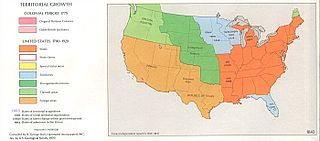
1970 USGS map
This image is in the public domain in the United States because it only contains materials that originally came from the United States Geological Survey, an agency of the United States Department of the Interior. For more information, see the official USGS copyright policy.
|
| US growth maps |
| Animated: large · small |
| Years |
| 1775 · 1790 · 1800 · 1810 · 1820 · 1830 · 1840 · 1850 · 1860 · 1870 · 1880 · 1900 · 1920 |
File history
Click on a date/time to view the file as it appeared at that time.
| Date/Time | Thumbnail | Dimensions | User | Comment | |
|---|---|---|---|---|---|
| current | 00:53, 19 January 2005 | | 1,400 × 616 (116 KB) | Exdaix | 1970 USGS map {{PD-USGov-USGS}} |
File usage
The following page uses this file:
Global file usage
The following other wikis use this file:
- Usage on en.wikipedia.org
- Usage on no.wikipedia.org