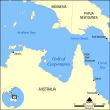
Gulf of Carpentaria
The Gulf of Carpentaria (14°00′S 139°00′E / 14.000°S 139.000°E) is a large, shallow sea surrounded on three sides by northern Australia. Its north edge is the Arafura Sea; the sea between Australia and New Guinea. At its mouth, the Gulf is 590 km wide, and further south, 675 km. The north south distance is more than 700 km. It covers a water area of about 300,000 km². The gulf is between 55 and 66 meters deep, although there are spots as deep as 82 meters.[1] In the last ice age the Gulf would have been dry land.


Geography change
The land around the Gulf is generally flat and low-lying. To the west is Arnhem Land, the Top End of the Northern Territory, and Groote Eylandt, the largest island in the Gulf. To the east is the Cape York Peninsula. The area to the south, is a part of Queensland) called the Gulf Country or simply "the Gulf."
The climate is hot and humid with two seasons per year. The dry season lasts from about April until November and is has very dry southeast to east winds, caused by winter high pressure systems to the south. The wet season lasts from December to March. Most of the year's rainfall is happens in these months, and many low-lying areas are flooded. The Gulf is also a breeding ground for tropical cyclones from November and April.
In September and October the Morning Glory cloud appears in the Southern Gulf. The best place to see this is in the Burketown area shortly after dawn.
European exploration change
The first known Europen person to visit the area was the Dutch Willem Janszoon (whose name is also written as Jansz) in his 1606 voyage. Jan Carstenszoon (or Carstensz), visited in 1623 and named the Gulf after Pieter de Carpentier, who was the Governor-General of the Dutch East Indies. Abel Tasman also explored the coast in 1644. The area was later explored and mapped by Matthew Flinders in 1802 and 1803.
The first overland expedition to reach the Gulf was the Burke and Wills expedition, led by Robert O'Hara Burke and William John Wills. They left Melbourne in August 1860 and reached the Bynoe River in February 1861.
Rivers of the Gulf change
References change
Other websites change
- Morning Glory Cloud video footage and video of the Gulf Region around Burketown
- Morning Glory Cloud meteorology
- Aerial Video of Sweers Island in the Gulf of Carpentaria
- Video of Burketown and the Gulf from the air
14°00′S 139°00′E / 14.000°S 139.000°E